You are here: Home > Network List > N4 - Central and EAstern US Network Stations List
> Station N35B Tabor, IA, USA > Earthquake Result Viewer
N35B Tabor, IA, USA - Earthquake Result Viewer
| Earthquake location: |
Alaska Peninsula |
| Earthquake latitude/longitude: |
54.4/-160.8 |
| Earthquake time(UTC): |
2018/07/19 (200) 14:16:27 GMT |
| Earthquake Depth: |
22 km |
| Earthquake Magnitude: |
5.8 Mww |
| Earthquake Catalog/Contributor: |
NEIC PDE/us |
|
| Network: |
N4 Central and EAstern US Network |
| Station: |
N35B Tabor, IA, USA |
| Lat/Lon: |
40.86 N/95.64 W |
| Elevation: |
353 m |
|
| Distance: |
44.3 deg |
| Az: |
79.957 deg |
| Baz: |
310.693 deg |
| Ray Param: |
0.07194377 |
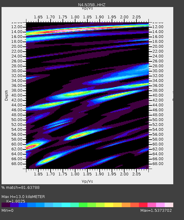
| Estimated Moho Depth: |
13.0 km |
| Estimated Crust Vp/Vs: |
1.80 |
| Assumed Crust Vp: |
6.498 km/s |
| Estimated Crust Vs: |
3.605 km/s |
| Estimated Crust Poisson's Ratio: |
0.28 |
|
| Radial Match: |
81.63788 % |
| Radial Bump: |
400 |
| Transverse Match: |
66.52724 % |
| Transverse Bump: |
400 |
| SOD ConfigId: |
13570011 |
| Insert Time: |
2019-04-30 14:36:44.609 +0000 |
| GWidth: |
2.5 |
| Max Bumps: |
400 |
| Tol: |
0.001 |
|

Signal To Noise
| Channel | StoN | STA | LTA |
| N4:N35B: :HHZ:20180719T14:24:04.890006Z | 2.889525 | 3.4547475E-7 | 1.1956108E-7 |
| N4:N35B: :HHN:20180719T14:24:04.890006Z | 2.0004752 | 3.5737074E-7 | 1.7864294E-7 |
| N4:N35B: :HHE:20180719T14:24:04.890006Z | 1.3856331 | 2.2900409E-7 | 1.6527036E-7 |
| Arrivals |
| Ps | 1.7 SECOND |
| PpPs | 5.3 SECOND |
| PsPs/PpSs | 7.0 SECOND |


