You are here: Home > Network List > TA - USArray Transportable Network (new EarthScope stations) Stations List
> Station A17A Triple J Farms, Joplin, MT, USA > Earthquake Result Viewer
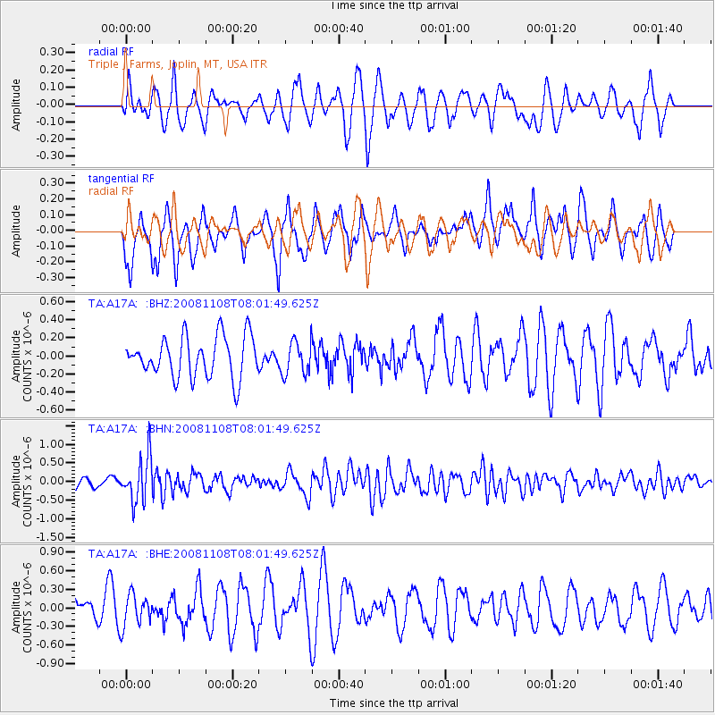
A17A Triple J Farms, Joplin, MT, USA - Earthquake Result Viewer
*The percent match for this event was below the threshold and hence no stack was calculated.
| Earthquake location: |
Tonga Islands |
| Earthquake latitude/longitude: |
-15.2/-174.2 |
| Earthquake time(UTC): |
2008/11/08 (313) 07:49:59 GMT |
| Earthquake Depth: |
121 km |
| Earthquake Magnitude: |
6.0 MW, 5.4 MB, 6.0 MW |
| Earthquake Catalog/Contributor: |
WHDF/NEIC |
|
| Network: |
TA USArray Transportable Network (new EarthScope stations) |
| Station: |
A17A Triple J Farms, Joplin, MT, USA |
| Lat/Lon: |
48.94 N/110.70 W |
| Elevation: |
973 m |
|
| Distance: |
85.0 deg |
| Az: |
36.332 deg |
| Baz: |
240.169 deg |
| Ray Param: |
$rayparam |
*The percent match for this event was below the threshold and hence was not used in the summary stack. |
|
| Radial Match: |
57.489254 % |
| Radial Bump: |
400 |
| Transverse Match: |
61.213978 % |
| Transverse Bump: |
390 |
| SOD ConfigId: |
2658 |
| Insert Time: |
2010-03-06 12:52:35.028 +0000 |
| GWidth: |
2.5 |
| Max Bumps: |
400 |
| Tol: |
0.001 |
|
Signal To Noise
| Channel | StoN | STA | LTA |
| TA:A17A: :BHN:20081108T08:01:49.625Z | 4.7416863 | 6.0335543E-7 | 1.272449E-7 |
| TA:A17A: :BHE:20081108T08:01:49.625Z | 1.4193425 | 2.5303294E-7 | 1.7827475E-7 |
| TA:A17A: :BHZ:20081108T08:01:49.625Z | 0.8288461 | 1.8750337E-7 | 2.2622218E-7 |
| Arrivals |
| Ps | |
| PpPs | |
| PsPs/PpSs | |


