You are here: Home > Network List > US - United States National Seismic Network Stations List
> Station AMTX Amarillo, Texas, USA > Earthquake Result Viewer
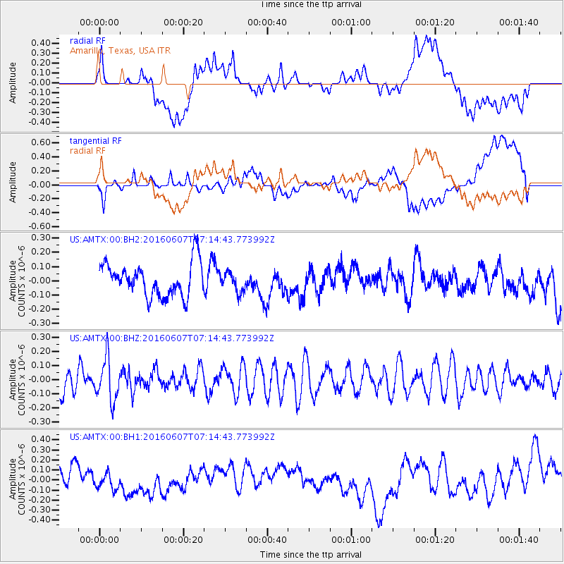
AMTX Amarillo, Texas, USA - Earthquake Result Viewer
*The percent match for this event was below the threshold and hence no stack was calculated.
| Earthquake location: |
South Of Fiji Islands |
| Earthquake latitude/longitude: |
-23.7/-179.9 |
| Earthquake time(UTC): |
2016/06/07 (159) 07:02:52 GMT |
| Earthquake Depth: |
523 km |
| Earthquake Magnitude: |
5.5 MB |
| Earthquake Catalog/Contributor: |
NEIC PDE/NEIC COMCAT |
|
| Network: |
US United States National Seismic Network |
| Station: |
AMTX Amarillo, Texas, USA |
| Lat/Lon: |
34.53 N/101.41 W |
| Elevation: |
1010 m |
|
| Distance: |
94.2 deg |
| Az: |
54.198 deg |
| Baz: |
244.265 deg |
| Ray Param: |
$rayparam |
*The percent match for this event was below the threshold and hence was not used in the summary stack. |
|
| Radial Match: |
39.857452 % |
| Radial Bump: |
400 |
| Transverse Match: |
41.931973 % |
| Transverse Bump: |
400 |
| SOD ConfigId: |
1609551 |
| Insert Time: |
2016-06-22 15:12:40.708 +0000 |
| GWidth: |
2.5 |
| Max Bumps: |
400 |
| Tol: |
0.001 |
|
Signal To Noise
| Channel | StoN | STA | LTA |
| US:AMTX:00:BHZ:20160607T07:14:43.773992Z | 1.8333862 | 1.5282902E-7 | 8.335888E-8 |
| US:AMTX:00:BH1:20160607T07:14:43.773992Z | 0.5555292 | 7.916683E-8 | 1.4250706E-7 |
| US:AMTX:00:BH2:20160607T07:14:43.773992Z | 0.5795465 | 6.8511135E-8 | 1.18215084E-7 |
| Arrivals |
| Ps | |
| PpPs | |
| PsPs/PpSs | |


