You are here: Home > Network List > TA - USArray Transportable Network (new EarthScope stations) Stations List
> Station A17A Triple J Farms, Joplin, MT, USA > Earthquake Result Viewer
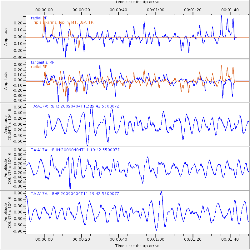
A17A Triple J Farms, Joplin, MT, USA - Earthquake Result Viewer
*The percent match for this event was below the threshold and hence no stack was calculated.
| Earthquake location: |
Tonga Islands Region |
| Earthquake latitude/longitude: |
-22.5/-174.7 |
| Earthquake time(UTC): |
2009/04/04 (094) 11:07:12 GMT |
| Earthquake Depth: |
35 km |
| Earthquake Magnitude: |
5.5 MB, 5.4 MS, 5.5 MW, 5.5 MW |
| Earthquake Catalog/Contributor: |
WHDF/NEIC |
|
| Network: |
TA USArray Transportable Network (new EarthScope stations) |
| Station: |
A17A Triple J Farms, Joplin, MT, USA |
| Lat/Lon: |
48.94 N/110.70 W |
| Elevation: |
973 m |
|
| Distance: |
91.1 deg |
| Az: |
36.331 deg |
| Baz: |
236.195 deg |
| Ray Param: |
$rayparam |
*The percent match for this event was below the threshold and hence was not used in the summary stack. |
|
| Radial Match: |
47.733887 % |
| Radial Bump: |
318 |
| Transverse Match: |
52.87522 % |
| Transverse Bump: |
240 |
| SOD ConfigId: |
2658 |
| Insert Time: |
2010-03-06 12:52:53.478 +0000 |
| GWidth: |
2.5 |
| Max Bumps: |
400 |
| Tol: |
0.001 |
|
Signal To Noise
| Channel | StoN | STA | LTA |
| TA:A17A: :BHN:20090404T11:19:42.550007Z | 1.8963964 | 3.5682936E-7 | 1.8816179E-7 |
| TA:A17A: :BHE:20090404T11:19:42.550007Z | 0.52212137 | 1.7090964E-7 | 3.2733698E-7 |
| TA:A17A: :BHZ:20090404T11:19:42.550007Z | 1.0047963 | 2.7108285E-7 | 2.6978887E-7 |
| Arrivals |
| Ps | |
| PpPs | |
| PsPs/PpSs | |


