You are here: Home > Network List > PY - PFO Array Stations List
> Station BPH09 Pinon Flat Observatory, CA, USA > Earthquake Result Viewer
BPH09 Pinon Flat Observatory, CA, USA - Earthquake Result Viewer
| Earthquake location: |
Alaska Peninsula |
| Earthquake latitude/longitude: |
54.4/-160.8 |
| Earthquake time(UTC): |
2018/07/19 (200) 14:16:27 GMT |
| Earthquake Depth: |
22 km |
| Earthquake Magnitude: |
5.8 Mww |
| Earthquake Catalog/Contributor: |
NEIC PDE/us |
|
| Network: |
PY PFO Array |
| Station: |
BPH09 Pinon Flat Observatory, CA, USA |
| Lat/Lon: |
33.61 N/116.46 W |
| Elevation: |
1295 m |
|
| Distance: |
37.3 deg |
| Az: |
105.592 deg |
| Baz: |
317.616 deg |
| Ray Param: |
0.07620219 |
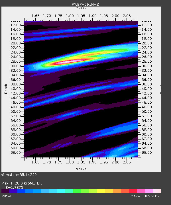
| Estimated Moho Depth: |
28.0 km |
| Estimated Crust Vp/Vs: |
1.79 |
| Assumed Crust Vp: |
6.264 km/s |
| Estimated Crust Vs: |
3.504 km/s |
| Estimated Crust Poisson's Ratio: |
0.27 |
|
| Radial Match: |
85.14342 % |
| Radial Bump: |
400 |
| Transverse Match: |
69.47408 % |
| Transverse Bump: |
400 |
| SOD ConfigId: |
13570011 |
| Insert Time: |
2019-04-30 14:39:10.769 +0000 |
| GWidth: |
2.5 |
| Max Bumps: |
400 |
| Tol: |
0.001 |
|

Signal To Noise
| Channel | StoN | STA | LTA |
| PY:BPH09: :HHZ:20180719T14:23:06.575004Z | 3.5489364 | 3.1423582E-7 | 8.854366E-8 |
| PY:BPH09: :HHN:20180719T14:23:06.575004Z | 3.176266 | 1.5553857E-7 | 4.8969003E-8 |
| PY:BPH09: :HHE:20180719T14:23:06.575004Z | 1.1490618 | 8.353019E-8 | 7.2694256E-8 |
| Arrivals |
| Ps | 3.8 SECOND |
| PpPs | 12 SECOND |
| PsPs/PpSs | 15 SECOND |


