You are here: Home > Network List > TA - USArray Transportable Network (new EarthScope stations) Stations List
> Station M53A WI Miller and Sons, Farmdale, OH, USA > Earthquake Result Viewer
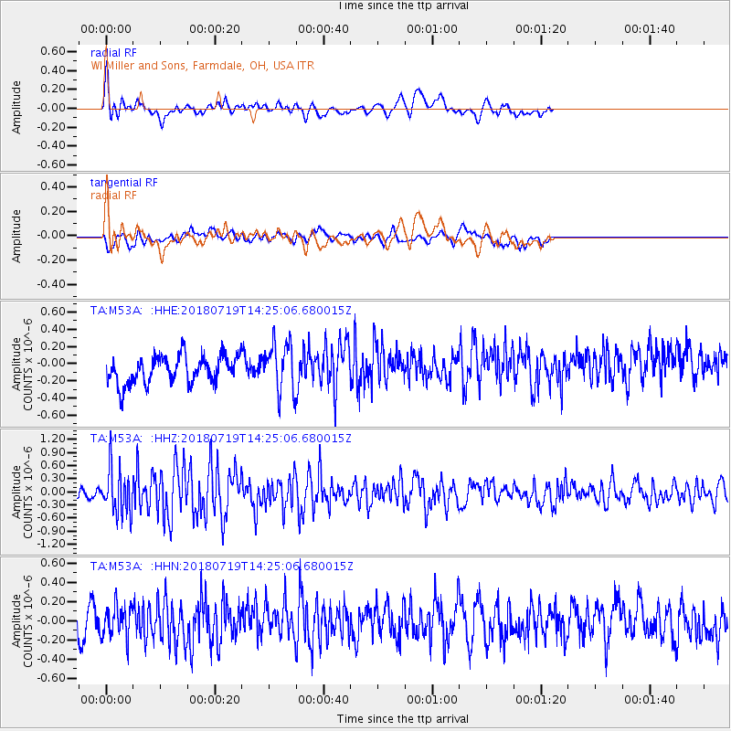
M53A WI Miller and Sons, Farmdale, OH, USA - Earthquake Result Viewer
*The percent match for this event was below the threshold and hence no stack was calculated.
| Earthquake location: |
Alaska Peninsula |
| Earthquake latitude/longitude: |
54.4/-160.8 |
| Earthquake time(UTC): |
2018/07/19 (200) 14:16:27 GMT |
| Earthquake Depth: |
22 km |
| Earthquake Magnitude: |
5.8 Mww |
| Earthquake Catalog/Contributor: |
NEIC PDE/us |
|
| Network: |
TA USArray Transportable Network (new EarthScope stations) |
| Station: |
M53A WI Miller and Sons, Farmdale, OH, USA |
| Lat/Lon: |
41.44 N/80.68 W |
| Elevation: |
334 m |
|
| Distance: |
52.4 deg |
| Az: |
69.27 deg |
| Baz: |
313.407 deg |
| Ray Param: |
$rayparam |
*The percent match for this event was below the threshold and hence was not used in the summary stack. |
|
| Radial Match: |
64.01256 % |
| Radial Bump: |
400 |
| Transverse Match: |
45.314964 % |
| Transverse Bump: |
400 |
| SOD ConfigId: |
13570011 |
| Insert Time: |
2019-04-30 14:39:41.412 +0000 |
| GWidth: |
2.5 |
| Max Bumps: |
400 |
| Tol: |
0.001 |
|
Signal To Noise
| Channel | StoN | STA | LTA |
| TA:M53A: :HHZ:20180719T14:25:06.680015Z | 4.0066237 | 5.253585E-7 | 1.3112248E-7 |
| TA:M53A: :HHN:20180719T14:25:06.680015Z | 1.3318733 | 1.6849506E-7 | 1.2650983E-7 |
| TA:M53A: :HHE:20180719T14:25:06.680015Z | 1.8204863 | 2.963943E-7 | 1.628105E-7 |
| Arrivals |
| Ps | |
| PpPs | |
| PsPs/PpSs | |


