You are here: Home > Network List > US - United States National Seismic Network Stations List
> Station MNTX Cornudas Mountains, Texas, USA > Earthquake Result Viewer
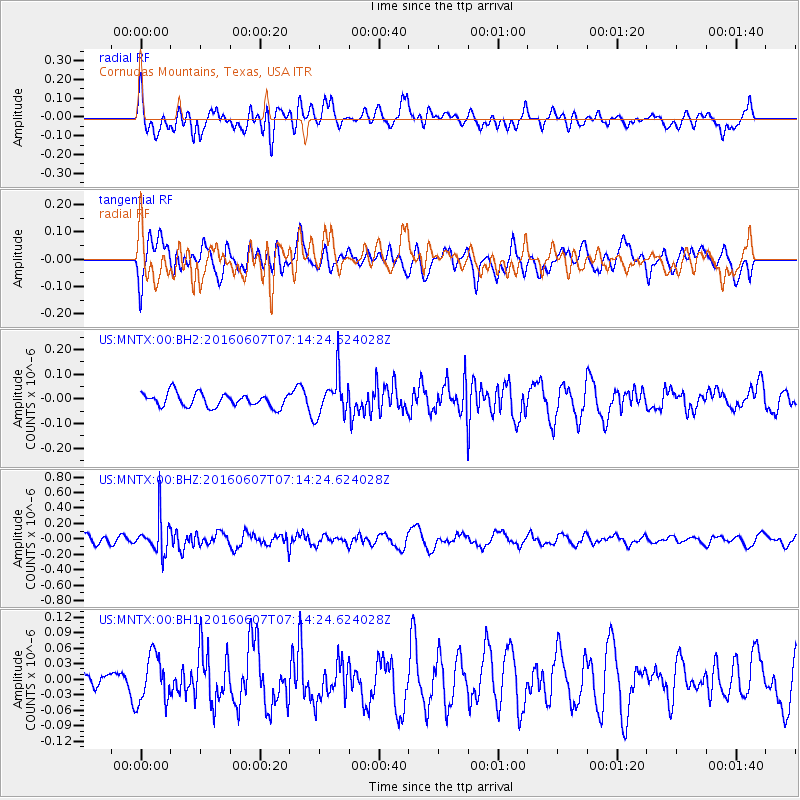
MNTX Cornudas Mountains, Texas, USA - Earthquake Result Viewer
*The percent match for this event was below the threshold and hence no stack was calculated.
| Earthquake location: |
South Of Fiji Islands |
| Earthquake latitude/longitude: |
-23.7/-179.9 |
| Earthquake time(UTC): |
2016/06/07 (159) 07:02:52 GMT |
| Earthquake Depth: |
523 km |
| Earthquake Magnitude: |
5.5 MB |
| Earthquake Catalog/Contributor: |
NEIC PDE/NEIC COMCAT |
|
| Network: |
US United States National Seismic Network |
| Station: |
MNTX Cornudas Mountains, Texas, USA |
| Lat/Lon: |
31.70 N/105.38 W |
| Elevation: |
404 m |
|
| Distance: |
90.0 deg |
| Az: |
55.212 deg |
| Baz: |
242.066 deg |
| Ray Param: |
$rayparam |
*The percent match for this event was below the threshold and hence was not used in the summary stack. |
|
| Radial Match: |
62.142 % |
| Radial Bump: |
400 |
| Transverse Match: |
39.975105 % |
| Transverse Bump: |
400 |
| SOD ConfigId: |
1609551 |
| Insert Time: |
2016-06-22 15:13:15.473 +0000 |
| GWidth: |
2.5 |
| Max Bumps: |
400 |
| Tol: |
0.001 |
|
Signal To Noise
| Channel | StoN | STA | LTA |
| US:MNTX:00:BHZ:20160607T07:14:24.624028Z | 3.4309459 | 2.1972225E-7 | 6.40413E-8 |
| US:MNTX:00:BH1:20160607T07:14:24.624028Z | 1.0929425 | 4.5325688E-8 | 4.1471246E-8 |
| US:MNTX:00:BH2:20160607T07:14:24.624028Z | 2.9307244 | 7.978944E-8 | 2.7225159E-8 |
| Arrivals |
| Ps | |
| PpPs | |
| PsPs/PpSs | |


