You are here: Home > Network List > CI - Caltech Regional Seismic Network Stations List
> Station MPP McPhearson Peak > Earthquake Result Viewer
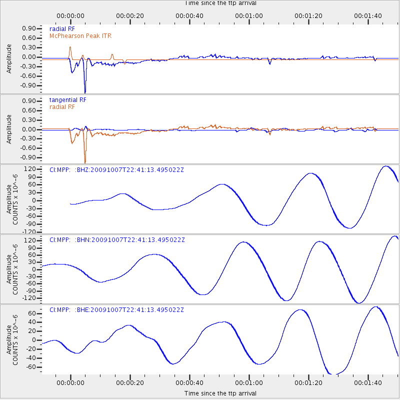
MPP McPhearson Peak - Earthquake Result Viewer
*The percent match for this event was below the threshold and hence no stack was calculated.
| Earthquake location: |
Santa Cruz Islands |
| Earthquake latitude/longitude: |
-11.5/166.0 |
| Earthquake time(UTC): |
2009/10/07 (280) 22:29:18 GMT |
| Earthquake Depth: |
35 km |
| Earthquake Magnitude: |
5.5 MB |
| Earthquake Catalog/Contributor: |
WHDF/NEIC |
|
| Network: |
CI Caltech Regional Seismic Network |
| Station: |
MPP McPhearson Peak |
| Lat/Lon: |
34.89 N/119.81 W |
| Elevation: |
1739 m |
|
| Distance: |
83.9 deg |
| Az: |
52.694 deg |
| Baz: |
251.511 deg |
| Ray Param: |
$rayparam |
*The percent match for this event was below the threshold and hence was not used in the summary stack. |
|
| Radial Match: |
94.35455 % |
| Radial Bump: |
400 |
| Transverse Match: |
89.68499 % |
| Transverse Bump: |
400 |
| SOD ConfigId: |
2622 |
| Insert Time: |
2010-02-26 02:05:39.863 +0000 |
| GWidth: |
2.5 |
| Max Bumps: |
400 |
| Tol: |
0.001 |
|
Signal To Noise
| Channel | StoN | STA | LTA |
| CI:MPP: :BHN:20091007T22:41:13.495022Z | 1.0259703 | 1.3899439E-5 | 1.3547603E-5 |
| CI:MPP: :BHE:20091007T22:41:13.495022Z | 2.4844308 | 2.7292568E-5 | 1.0985441E-5 |
| CI:MPP: :BHZ:20091007T22:41:13.495022Z | 2.801757 | 3.6085075E-5 | 1.2879444E-5 |
| Arrivals |
| Ps | |
| PpPs | |
| PsPs/PpSs | |


