You are here: Home > Network List > TA - USArray Transportable Network (new EarthScope stations) Stations List
> Station A17A Triple J Farms, Joplin, MT, USA > Earthquake Result Viewer
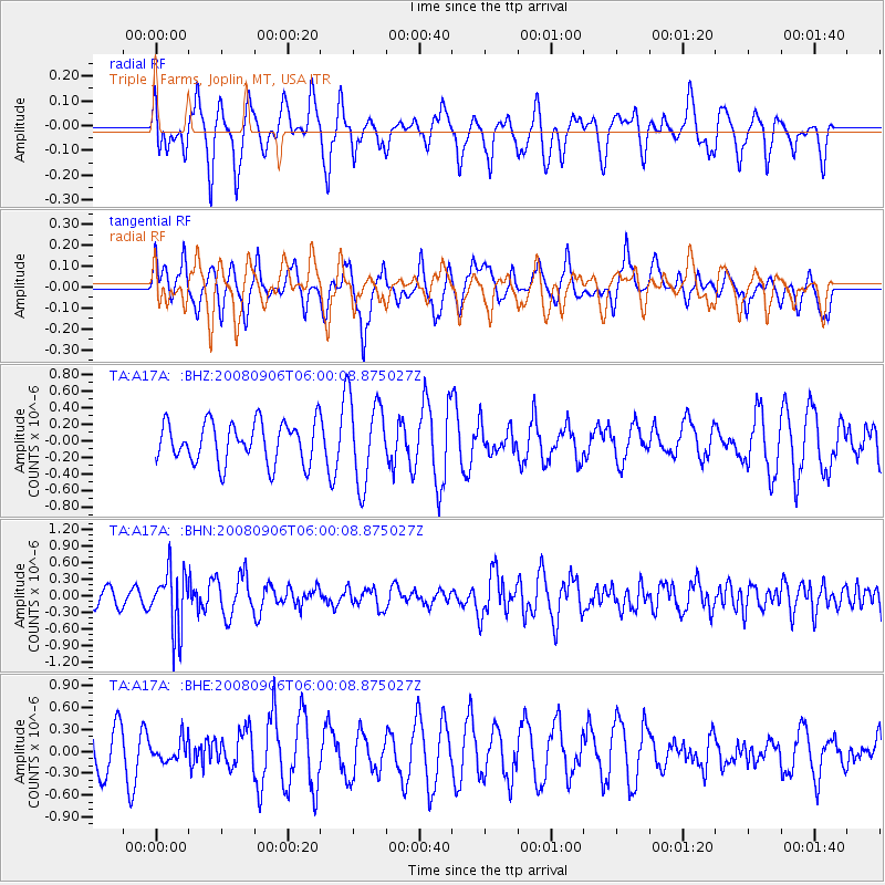
A17A Triple J Farms, Joplin, MT, USA - Earthquake Result Viewer
*The percent match for this event was below the threshold and hence no stack was calculated.
| Earthquake location: |
Hindu Kush Region, Afghanistan |
| Earthquake latitude/longitude: |
36.5/70.9 |
| Earthquake time(UTC): |
2008/09/06 (250) 05:47:39 GMT |
| Earthquake Depth: |
192 km |
| Earthquake Magnitude: |
5.5 MB, 5.8 MW, 5.8 MW |
| Earthquake Catalog/Contributor: |
WHDF/NEIC |
|
| Network: |
TA USArray Transportable Network (new EarthScope stations) |
| Station: |
A17A Triple J Farms, Joplin, MT, USA |
| Lat/Lon: |
48.94 N/110.70 W |
| Elevation: |
973 m |
|
| Distance: |
94.9 deg |
| Az: |
1.081 deg |
| Baz: |
358.679 deg |
| Ray Param: |
$rayparam |
*The percent match for this event was below the threshold and hence was not used in the summary stack. |
|
| Radial Match: |
47.3219 % |
| Radial Bump: |
384 |
| Transverse Match: |
59.858177 % |
| Transverse Bump: |
400 |
| SOD ConfigId: |
2560 |
| Insert Time: |
2010-03-06 12:53:27.893 +0000 |
| GWidth: |
2.5 |
| Max Bumps: |
400 |
| Tol: |
0.001 |
|
Signal To Noise
| Channel | StoN | STA | LTA |
| TA:A17A: :BHN:20080906T06:00:08.875027Z | 2.3759687 | 5.3440266E-7 | 2.2491992E-7 |
| TA:A17A: :BHE:20080906T06:00:08.875027Z | 0.51305026 | 1.431188E-7 | 2.789567E-7 |
| TA:A17A: :BHZ:20080906T06:00:08.875027Z | 2.083867 | 5.1114074E-7 | 2.4528472E-7 |
| Arrivals |
| Ps | |
| PpPs | |
| PsPs/PpSs | |


