You are here: Home > Network List > CI - Caltech Regional Seismic Network Stations List
> Station MPP McPhearson Peak > Earthquake Result Viewer
MPP McPhearson Peak - Earthquake Result Viewer
*The percent match for this event was below the threshold and hence no stack was calculated.
| Earthquake location: |
Santa Cruz Islands |
| Earthquake latitude/longitude: |
-12.4/166.5 |
| Earthquake time(UTC): |
2009/10/12 (285) 09:37:21 GMT |
| Earthquake Depth: |
42 km |
| Earthquake Magnitude: |
5.9 MB, 5.9 MS, 6.2 MW, 6.2 MW |
| Earthquake Catalog/Contributor: |
WHDF/NEIC |
|
| Network: |
CI Caltech Regional Seismic Network |
| Station: |
MPP McPhearson Peak |
| Lat/Lon: |
34.89 N/119.81 W |
| Elevation: |
1739 m |
|
| Distance: |
84.0 deg |
| Az: |
52.492 deg |
| Baz: |
250.511 deg |
| Ray Param: |
$rayparam |
*The percent match for this event was below the threshold and hence was not used in the summary stack. |
|
| Radial Match: |
68.62295 % |
| Radial Bump: |
400 |
| Transverse Match: |
67.27912 % |
| Transverse Bump: |
400 |
| SOD ConfigId: |
2622 |
| Insert Time: |
2010-02-26 02:05:42.439 +0000 |
| GWidth: |
2.5 |
| Max Bumps: |
400 |
| Tol: |
0.001 |
|
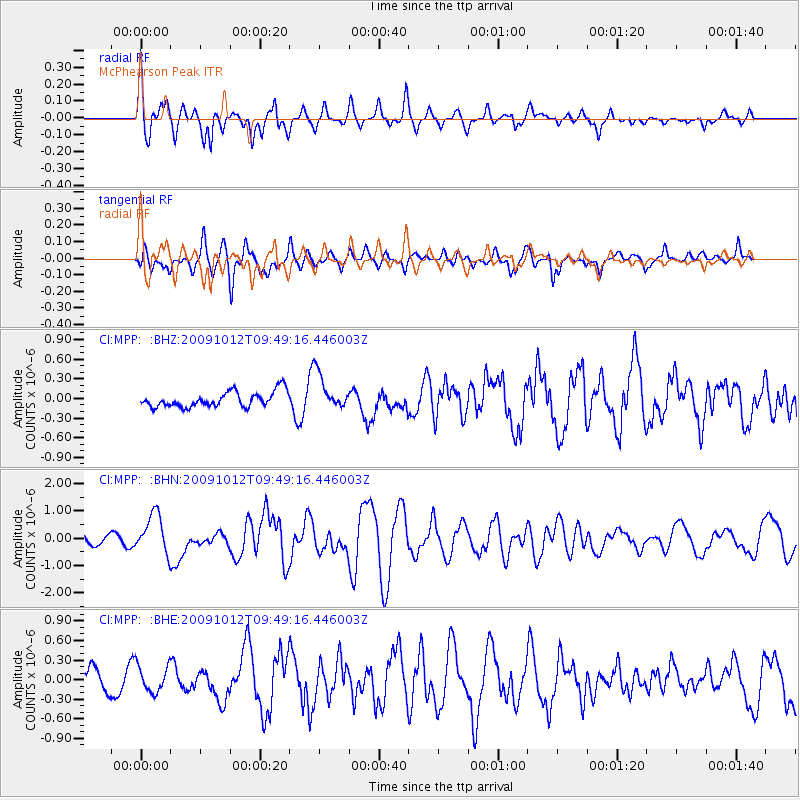
Signal To Noise
| Channel | StoN | STA | LTA |
| CI:MPP: :BHN:20091012T09:49:16.446003Z | 4.2561016 | 7.2347586E-7 | 1.6998557E-7 |
| CI:MPP: :BHE:20091012T09:49:16.446003Z | 0.9909793 | 2.0256981E-7 | 2.0441377E-7 |
| CI:MPP: :BHZ:20091012T09:49:16.446003Z | 2.322773 | 2.742334E-7 | 1.1806294E-7 |
| Arrivals |
| Ps | |
| PpPs | |
| PsPs/PpSs | |


