You are here: Home > Network List > US - United States National Seismic Network Stations List
> Station WUAZ Wupatki, Arizona, USA > Earthquake Result Viewer
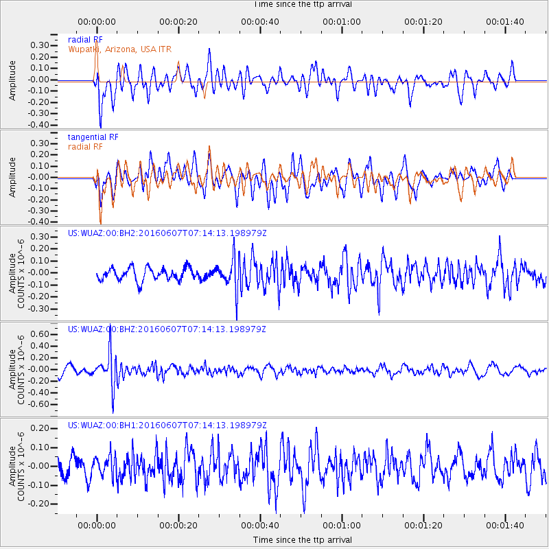
WUAZ Wupatki, Arizona, USA - Earthquake Result Viewer
*The percent match for this event was below the threshold and hence no stack was calculated.
| Earthquake location: |
South Of Fiji Islands |
| Earthquake latitude/longitude: |
-23.7/-179.9 |
| Earthquake time(UTC): |
2016/06/07 (159) 07:02:52 GMT |
| Earthquake Depth: |
523 km |
| Earthquake Magnitude: |
5.5 MB |
| Earthquake Catalog/Contributor: |
NEIC PDE/NEIC COMCAT |
|
| Network: |
US United States National Seismic Network |
| Station: |
WUAZ Wupatki, Arizona, USA |
| Lat/Lon: |
35.52 N/111.37 W |
| Elevation: |
1592 m |
|
| Distance: |
87.5 deg |
| Az: |
49.431 deg |
| Baz: |
238.633 deg |
| Ray Param: |
$rayparam |
*The percent match for this event was below the threshold and hence was not used in the summary stack. |
|
| Radial Match: |
58.279663 % |
| Radial Bump: |
400 |
| Transverse Match: |
59.64984 % |
| Transverse Bump: |
385 |
| SOD ConfigId: |
1609551 |
| Insert Time: |
2016-06-22 15:13:45.560 +0000 |
| GWidth: |
2.5 |
| Max Bumps: |
400 |
| Tol: |
0.001 |
|
Signal To Noise
| Channel | StoN | STA | LTA |
| US:WUAZ:00:BHZ:20160607T07:14:13.198979Z | 4.852605 | 2.8345434E-7 | 5.8412816E-8 |
| US:WUAZ:00:BH1:20160607T07:14:13.198979Z | 0.86528337 | 5.059648E-8 | 5.8473884E-8 |
| US:WUAZ:00:BH2:20160607T07:14:13.198979Z | 2.5045936 | 1.2943266E-7 | 5.1678107E-8 |
| Arrivals |
| Ps | |
| PpPs | |
| PsPs/PpSs | |


