You are here: Home > Network List > CI - Caltech Regional Seismic Network Stations List
> Station MPP McPhearson Peak > Earthquake Result Viewer
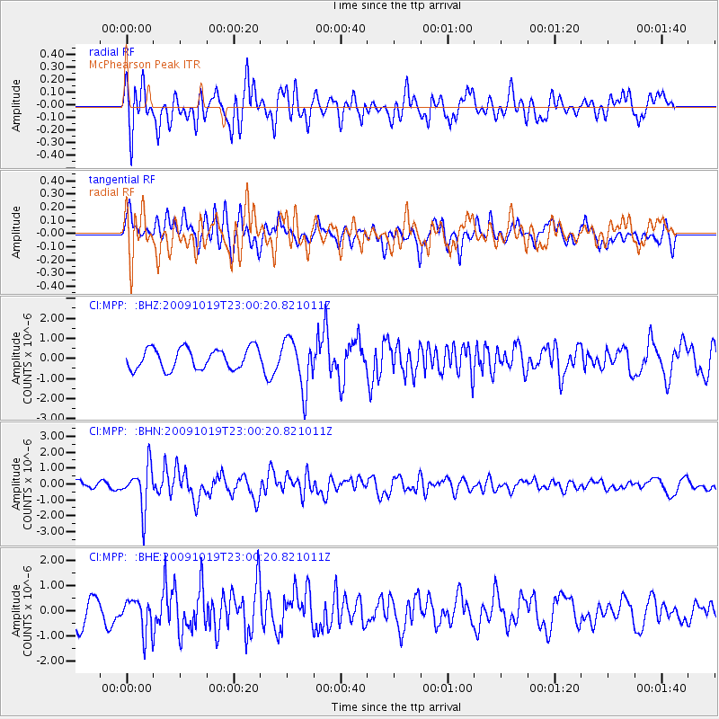
MPP McPhearson Peak - Earthquake Result Viewer
*The percent match for this event was below the threshold and hence no stack was calculated.
| Earthquake location: |
Samoa Islands Region |
| Earthquake latitude/longitude: |
-15.4/-172.3 |
| Earthquake time(UTC): |
2009/10/19 (292) 22:49:38 GMT |
| Earthquake Depth: |
18 km |
| Earthquake Magnitude: |
6.2 MB, 5.7 MS, 6.0 MW, 5.9 MW |
| Earthquake Catalog/Contributor: |
WHDF/NEIC |
|
| Network: |
CI Caltech Regional Seismic Network |
| Station: |
MPP McPhearson Peak |
| Lat/Lon: |
34.89 N/119.81 W |
| Elevation: |
1739 m |
|
| Distance: |
70.5 deg |
| Az: |
43.735 deg |
| Baz: |
234.223 deg |
| Ray Param: |
$rayparam |
*The percent match for this event was below the threshold and hence was not used in the summary stack. |
|
| Radial Match: |
42.265995 % |
| Radial Bump: |
398 |
| Transverse Match: |
51.206833 % |
| Transverse Bump: |
400 |
| SOD ConfigId: |
2622 |
| Insert Time: |
2010-02-26 02:05:47.855 +0000 |
| GWidth: |
2.5 |
| Max Bumps: |
400 |
| Tol: |
0.001 |
|
Signal To Noise
| Channel | StoN | STA | LTA |
| CI:MPP: :BHN:20091019T23:00:20.821011Z | 4.91318 | 1.3433234E-6 | 2.7341224E-7 |
| CI:MPP: :BHE:20091019T23:00:20.821011Z | 1.1635287 | 6.9164565E-7 | 5.9443795E-7 |
| CI:MPP: :BHZ:20091019T23:00:20.821011Z | 2.4350555 | 1.2526403E-6 | 5.1441964E-7 |
| Arrivals |
| Ps | |
| PpPs | |
| PsPs/PpSs | |


