You are here: Home > Network List > CI - Caltech Regional Seismic Network Stations List
> Station MPP McPhearson Peak > Earthquake Result Viewer
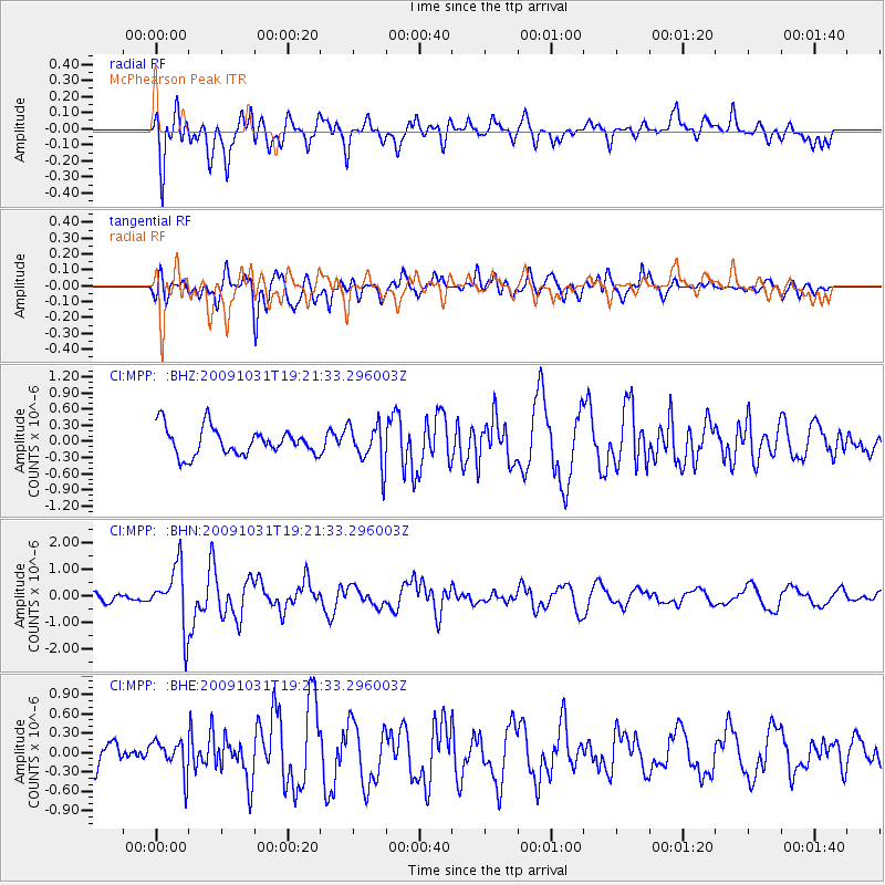
MPP McPhearson Peak - Earthquake Result Viewer
*The percent match for this event was below the threshold and hence no stack was calculated.
| Earthquake location: |
Santa Cruz Islands |
| Earthquake latitude/longitude: |
-11.4/166.4 |
| Earthquake time(UTC): |
2009/10/31 (304) 19:09:51 GMT |
| Earthquake Depth: |
134 km |
| Earthquake Magnitude: |
5.9 MB, 5.9 MW, 5.9 MW |
| Earthquake Catalog/Contributor: |
WHDF/NEIC |
|
| Network: |
CI Caltech Regional Seismic Network |
| Station: |
MPP McPhearson Peak |
| Lat/Lon: |
34.89 N/119.81 W |
| Elevation: |
1739 m |
|
| Distance: |
83.5 deg |
| Az: |
52.615 deg |
| Baz: |
251.408 deg |
| Ray Param: |
$rayparam |
*The percent match for this event was below the threshold and hence was not used in the summary stack. |
|
| Radial Match: |
76.29428 % |
| Radial Bump: |
400 |
| Transverse Match: |
65.11587 % |
| Transverse Bump: |
400 |
| SOD ConfigId: |
2622 |
| Insert Time: |
2010-02-26 02:05:52.042 +0000 |
| GWidth: |
2.5 |
| Max Bumps: |
400 |
| Tol: |
0.001 |
|
Signal To Noise
| Channel | StoN | STA | LTA |
| CI:MPP: :BHN:20091031T19:21:33.296003Z | 4.9525957 | 1.135539E-6 | 2.292816E-7 |
| CI:MPP: :BHE:20091031T19:21:33.296003Z | 1.013182 | 2.5768693E-7 | 2.543343E-7 |
| CI:MPP: :BHZ:20091031T19:21:33.296003Z | 1.5049728 | 3.823949E-7 | 2.5408755E-7 |
| Arrivals |
| Ps | |
| PpPs | |
| PsPs/PpSs | |


