You are here: Home > Network List > TA - USArray Transportable Network (new EarthScope stations) Stations List
> Station J26L Joseph Creek, AK, USA > Earthquake Result Viewer
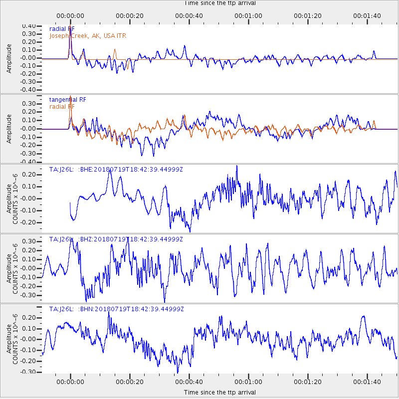
J26L Joseph Creek, AK, USA - Earthquake Result Viewer
*The percent match for this event was below the threshold and hence no stack was calculated.
| Earthquake location: |
New Britain Region, P.N.G. |
| Earthquake latitude/longitude: |
-6.1/148.7 |
| Earthquake time(UTC): |
2018/07/19 (200) 18:30:32 GMT |
| Earthquake Depth: |
30 km |
| Earthquake Magnitude: |
6.0 Mww |
| Earthquake Catalog/Contributor: |
NEIC PDE/us |
|
| Network: |
TA USArray Transportable Network (new EarthScope stations) |
| Station: |
J26L Joseph Creek, AK, USA |
| Lat/Lon: |
64.50 N/143.56 W |
| Elevation: |
1144 m |
|
| Distance: |
86.1 deg |
| Az: |
23.667 deg |
| Baz: |
247.248 deg |
| Ray Param: |
$rayparam |
*The percent match for this event was below the threshold and hence was not used in the summary stack. |
|
| Radial Match: |
71.059 % |
| Radial Bump: |
400 |
| Transverse Match: |
46.38125 % |
| Transverse Bump: |
400 |
| SOD ConfigId: |
13570011 |
| Insert Time: |
2019-04-30 14:47:20.919 +0000 |
| GWidth: |
2.5 |
| Max Bumps: |
400 |
| Tol: |
0.001 |
|
Signal To Noise
| Channel | StoN | STA | LTA |
| TA:J26L: :BHZ:20180719T18:42:39.44999Z | 4.5269604 | 2.1301278E-7 | 4.705426E-8 |
| TA:J26L: :BHN:20180719T18:42:39.44999Z | 1.1551157 | 1.1480364E-7 | 9.938714E-8 |
| TA:J26L: :BHE:20180719T18:42:39.44999Z | 1.6138285 | 1.3401709E-7 | 8.3042956E-8 |
| Arrivals |
| Ps | |
| PpPs | |
| PsPs/PpSs | |


