You are here: Home > Network List > CI - Caltech Regional Seismic Network Stations List
> Station MPP McPhearson Peak > Earthquake Result Viewer
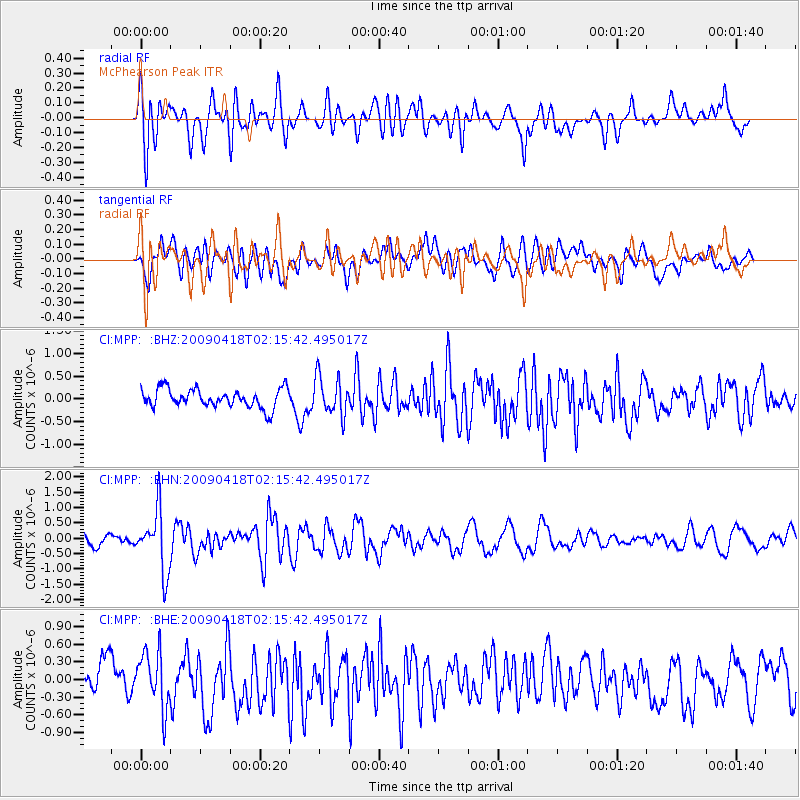
MPP McPhearson Peak - Earthquake Result Viewer
*The percent match for this event was below the threshold and hence no stack was calculated.
| Earthquake location: |
Kermadec Islands Region |
| Earthquake latitude/longitude: |
-28.9/-177.4 |
| Earthquake time(UTC): |
2009/04/18 (108) 02:03:52 GMT |
| Earthquake Depth: |
65 km |
| Earthquake Magnitude: |
6.0 MB, 5.8 MW, 5.7 MW |
| Earthquake Catalog/Contributor: |
WHDF/NEIC |
|
| Network: |
CI Caltech Regional Seismic Network |
| Station: |
MPP McPhearson Peak |
| Lat/Lon: |
34.89 N/119.81 W |
| Elevation: |
1739 m |
|
| Distance: |
83.6 deg |
| Az: |
44.325 deg |
| Baz: |
228.174 deg |
| Ray Param: |
$rayparam |
*The percent match for this event was below the threshold and hence was not used in the summary stack. |
|
| Radial Match: |
76.241646 % |
| Radial Bump: |
400 |
| Transverse Match: |
52.056816 % |
| Transverse Bump: |
400 |
| SOD ConfigId: |
2658 |
| Insert Time: |
2010-02-26 02:05:53.562 +0000 |
| GWidth: |
2.5 |
| Max Bumps: |
400 |
| Tol: |
0.001 |
|
Signal To Noise
| Channel | StoN | STA | LTA |
| CI:MPP: :BHN:20090418T02:15:42.495017Z | 4.416167 | 9.862753E-7 | 2.2333289E-7 |
| CI:MPP: :BHE:20090418T02:15:42.495017Z | 1.5845037 | 4.6684727E-7 | 2.9463314E-7 |
| CI:MPP: :BHZ:20090418T02:15:42.495017Z | 2.065285 | 4.244982E-7 | 2.0553976E-7 |
| Arrivals |
| Ps | |
| PpPs | |
| PsPs/PpSs | |


