You are here: Home > Network List > CI - Caltech Regional Seismic Network Stations List
> Station MPP McPhearson Peak > Earthquake Result Viewer
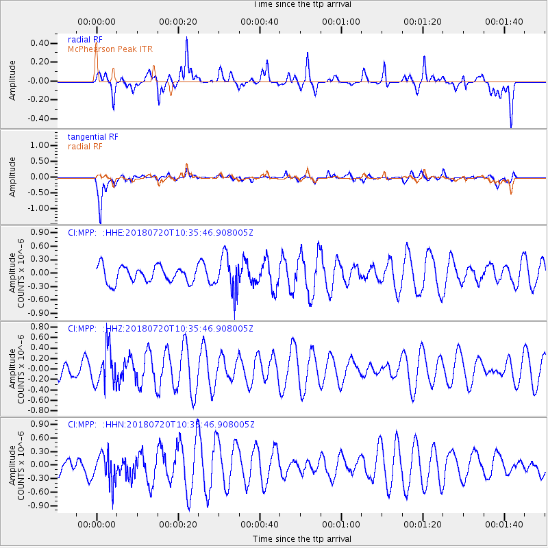
MPP McPhearson Peak - Earthquake Result Viewer
*The percent match for this event was below the threshold and hence no stack was calculated.
| Earthquake location: |
Santiago Del Estero Prov., Arg. |
| Earthquake latitude/longitude: |
-28.1/-63.3 |
| Earthquake time(UTC): |
2018/07/20 (201) 10:24:57 GMT |
| Earthquake Depth: |
588 km |
| Earthquake Magnitude: |
5.6 Mww |
| Earthquake Catalog/Contributor: |
NEIC PDE/us |
|
| Network: |
CI Caltech Regional Seismic Network |
| Station: |
MPP McPhearson Peak |
| Lat/Lon: |
34.89 N/119.81 W |
| Elevation: |
1739 m |
|
| Distance: |
82.3 deg |
| Az: |
316.195 deg |
| Baz: |
131.919 deg |
| Ray Param: |
$rayparam |
*The percent match for this event was below the threshold and hence was not used in the summary stack. |
|
| Radial Match: |
57.503036 % |
| Radial Bump: |
400 |
| Transverse Match: |
77.35278 % |
| Transverse Bump: |
400 |
| SOD ConfigId: |
13570011 |
| Insert Time: |
2019-04-30 14:50:53.309 +0000 |
| GWidth: |
2.5 |
| Max Bumps: |
400 |
| Tol: |
0.001 |
|
Signal To Noise
| Channel | StoN | STA | LTA |
| CI:MPP: :HHZ:20180720T10:35:46.908005Z | 2.589947 | 3.5563775E-7 | 1.3731469E-7 |
| CI:MPP: :HHN:20180720T10:35:46.908005Z | 1.1555055 | 3.259044E-7 | 2.8204488E-7 |
| CI:MPP: :HHE:20180720T10:35:46.908005Z | 2.2734828 | 4.0546087E-7 | 1.783435E-7 |
| Arrivals |
| Ps | |
| PpPs | |
| PsPs/PpSs | |


