You are here: Home > Network List > TA - USArray Transportable Network (new EarthScope stations) Stations List
> Station 222A Williams Family Ranch, Las Cruces, NM, USA > Earthquake Result Viewer
222A Williams Family Ranch, Las Cruces, NM, USA - Earthquake Result Viewer
| Earthquake location: |
Kermadec Islands Region |
| Earthquake latitude/longitude: |
-27.4/-176.3 |
| Earthquake time(UTC): |
2009/02/18 (049) 21:53:45 GMT |
| Earthquake Depth: |
25 km |
| Earthquake Magnitude: |
6.8 MB, 7.2 MS, 6.9 MW, 6.9 MW |
| Earthquake Catalog/Contributor: |
WHDF/NEIC |
|
| Network: |
TA USArray Transportable Network (new EarthScope stations) |
| Station: |
222A Williams Family Ranch, Las Cruces, NM, USA |
| Lat/Lon: |
32.10 N/107.10 W |
| Elevation: |
1324 m |
|
| Distance: |
88.6 deg |
| Az: |
52.539 deg |
| Baz: |
236.24 deg |
| Ray Param: |
0.042472865 |
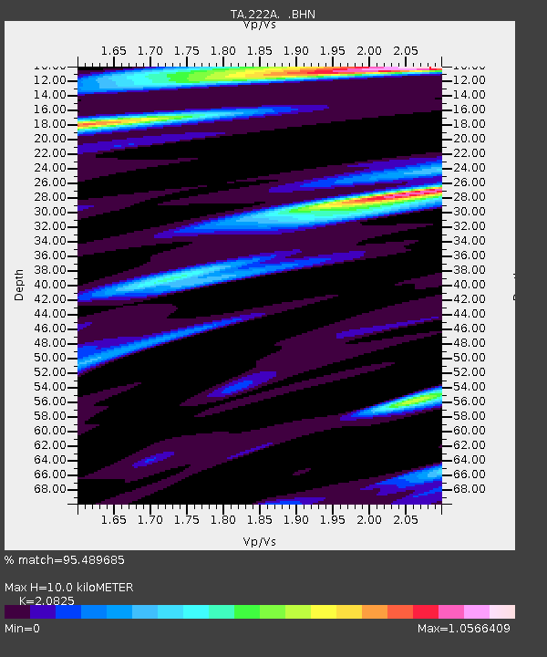
| Estimated Moho Depth: |
10.0 km |
| Estimated Crust Vp/Vs: |
2.08 |
| Assumed Crust Vp: |
6.502 km/s |
| Estimated Crust Vs: |
3.122 km/s |
| Estimated Crust Poisson's Ratio: |
0.35 |
|
| Radial Match: |
95.489685 % |
| Radial Bump: |
400 |
| Transverse Match: |
90.095245 % |
| Transverse Bump: |
400 |
| SOD ConfigId: |
2658 |
| Insert Time: |
2010-03-06 12:56:39.937 +0000 |
| GWidth: |
2.5 |
| Max Bumps: |
400 |
| Tol: |
0.001 |
|

Signal To Noise
| Channel | StoN | STA | LTA |
| TA:222A: :BHN:20090218T22:06:04.225002Z | 12.955574 | 3.5884682E-6 | 2.7698258E-7 |
| TA:222A: :BHE:20090218T22:06:04.225002Z | 2.8197699 | 6.480872E-7 | 2.2983691E-7 |
| TA:222A: :BHZ:20090218T22:06:04.225002Z | 2.3614483 | 7.944752E-7 | 3.3643556E-7 |
| Arrivals |
| Ps | 1.7 SECOND |
| PpPs | 4.7 SECOND |
| PsPs/PpSs | 6.3 SECOND |


