You are here: Home > Network List > TA - USArray Transportable Network (new EarthScope stations) Stations List
> Station 222A Williams Family Ranch, Las Cruces, NM, USA > Earthquake Result Viewer
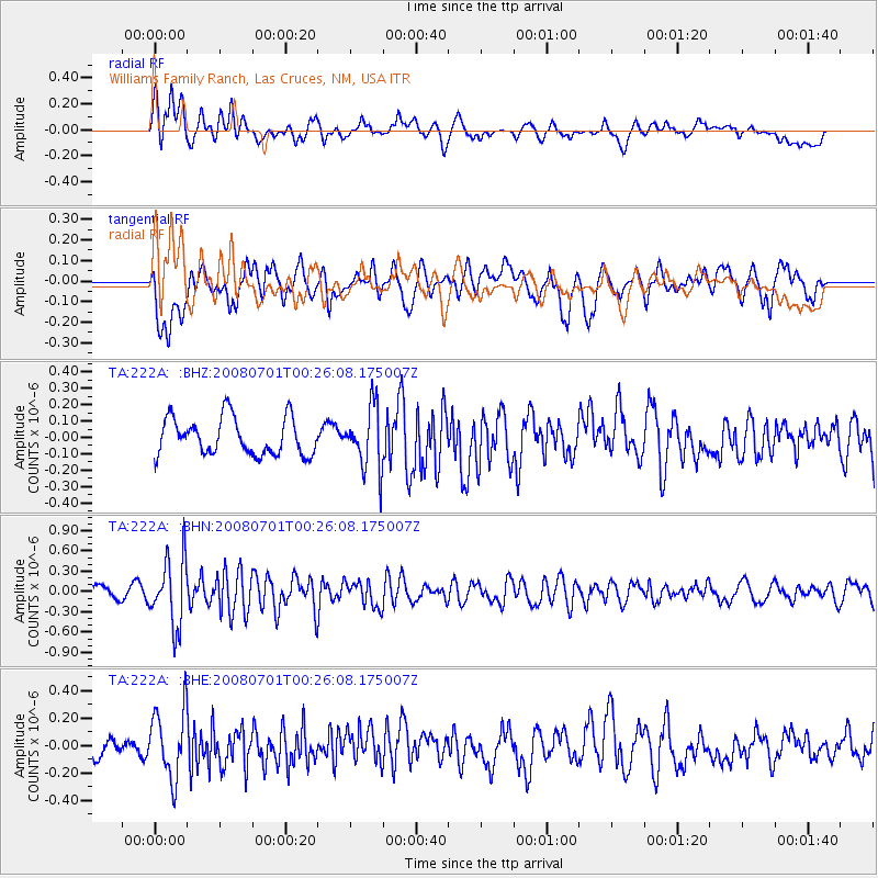
222A Williams Family Ranch, Las Cruces, NM, USA - Earthquake Result Viewer
*The percent match for this event was below the threshold and hence no stack was calculated.
| Earthquake location: |
Central Peru |
| Earthquake latitude/longitude: |
-10.4/-75.5 |
| Earthquake time(UTC): |
2008/07/01 (183) 00:17:33 GMT |
| Earthquake Depth: |
33 km |
| Earthquake Magnitude: |
5.5 MW, 5.0 MS, 5.4 MB, 5.3 ML |
| Earthquake Catalog/Contributor: |
WHDF/NEIC |
|
| Network: |
TA USArray Transportable Network (new EarthScope stations) |
| Station: |
222A Williams Family Ranch, Las Cruces, NM, USA |
| Lat/Lon: |
32.10 N/107.10 W |
| Elevation: |
1324 m |
|
| Distance: |
51.9 deg |
| Az: |
325.616 deg |
| Baz: |
139.102 deg |
| Ray Param: |
$rayparam |
*The percent match for this event was below the threshold and hence was not used in the summary stack. |
|
| Radial Match: |
70.596275 % |
| Radial Bump: |
400 |
| Transverse Match: |
63.9256 % |
| Transverse Bump: |
400 |
| SOD ConfigId: |
2504 |
| Insert Time: |
2010-03-06 12:57:50.477 +0000 |
| GWidth: |
2.5 |
| Max Bumps: |
400 |
| Tol: |
0.001 |
|
Signal To Noise
| Channel | StoN | STA | LTA |
| TA:222A: :BHN:20080701T00:26:08.175007Z | 4.9969435 | 4.927759E-7 | 9.861546E-8 |
| TA:222A: :BHE:20080701T00:26:08.175007Z | 2.5910144 | 2.49521E-7 | 9.6302436E-8 |
| TA:222A: :BHZ:20080701T00:26:08.175007Z | 1.6634705 | 1.888416E-7 | 1.1352265E-7 |
| Arrivals |
| Ps | |
| PpPs | |
| PsPs/PpSs | |


