You are here: Home > Network List > CI - Caltech Regional Seismic Network Stations List
> Station MPM Manuel Prospect Mine, California, USA > Earthquake Result Viewer
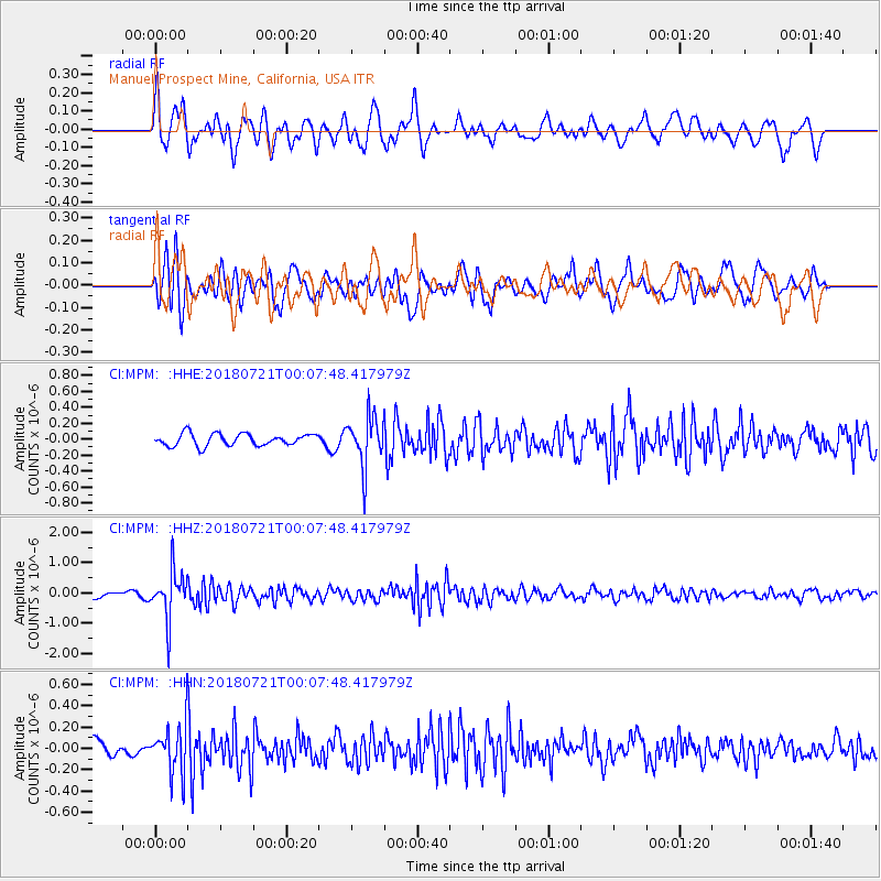
MPM Manuel Prospect Mine, California, USA - Earthquake Result Viewer
*The percent match for this event was below the threshold and hence no stack was calculated.
| Earthquake location: |
Mariana Islands |
| Earthquake latitude/longitude: |
18.5/146.0 |
| Earthquake time(UTC): |
2018/07/20 (201) 23:56:00 GMT |
| Earthquake Depth: |
126 km |
| Earthquake Magnitude: |
5.6 Mww |
| Earthquake Catalog/Contributor: |
NEIC PDE/us |
|
| Network: |
CI Caltech Regional Seismic Network |
| Station: |
MPM Manuel Prospect Mine, California, USA |
| Lat/Lon: |
36.06 N/117.49 W |
| Elevation: |
185 m |
|
| Distance: |
84.4 deg |
| Az: |
53.989 deg |
| Baz: |
288.649 deg |
| Ray Param: |
$rayparam |
*The percent match for this event was below the threshold and hence was not used in the summary stack. |
|
| Radial Match: |
75.63618 % |
| Radial Bump: |
400 |
| Transverse Match: |
73.21788 % |
| Transverse Bump: |
400 |
| SOD ConfigId: |
13570011 |
| Insert Time: |
2019-04-30 15:02:44.776 +0000 |
| GWidth: |
2.5 |
| Max Bumps: |
400 |
| Tol: |
0.001 |
|
Signal To Noise
| Channel | StoN | STA | LTA |
| CI:MPM: :HHZ:20180721T00:07:48.417979Z | 12.380756 | 7.882596E-7 | 6.366813E-8 |
| CI:MPM: :HHN:20180721T00:07:48.417979Z | 2.5987628 | 2.3719011E-7 | 9.1270394E-8 |
| CI:MPM: :HHE:20180721T00:07:48.417979Z | 4.137089 | 3.1285194E-7 | 7.562127E-8 |
| Arrivals |
| Ps | |
| PpPs | |
| PsPs/PpSs | |


