You are here: Home > Network List > CN - Canadian National Seismograph Network Stations List
> Station INK INUVIK, NT > Earthquake Result Viewer
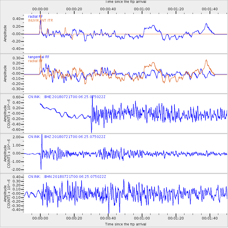
INK INUVIK, NT - Earthquake Result Viewer
*The percent match for this event was below the threshold and hence no stack was calculated.
| Earthquake location: |
Mariana Islands |
| Earthquake latitude/longitude: |
18.5/146.0 |
| Earthquake time(UTC): |
2018/07/20 (201) 23:56:00 GMT |
| Earthquake Depth: |
126 km |
| Earthquake Magnitude: |
5.6 Mww |
| Earthquake Catalog/Contributor: |
NEIC PDE/us |
|
| Network: |
CN Canadian National Seismograph Network |
| Station: |
INK INUVIK, NT |
| Lat/Lon: |
68.31 N/133.53 W |
| Elevation: |
44 m |
|
| Distance: |
69.5 deg |
| Az: |
23.05 deg |
| Baz: |
268.244 deg |
| Ray Param: |
$rayparam |
*The percent match for this event was below the threshold and hence was not used in the summary stack. |
|
| Radial Match: |
33.874977 % |
| Radial Bump: |
400 |
| Transverse Match: |
70.08494 % |
| Transverse Bump: |
400 |
| SOD ConfigId: |
13570011 |
| Insert Time: |
2019-04-30 15:03:19.493 +0000 |
| GWidth: |
2.5 |
| Max Bumps: |
400 |
| Tol: |
0.001 |
|
Signal To Noise
| Channel | StoN | STA | LTA |
| CN:INK: :BHZ:20180721T00:06:25.075022Z | 11.628534 | 6.798876E-7 | 5.846718E-8 |
| CN:INK: :BHN:20180721T00:06:25.075022Z | 2.5096154 | 1.2923793E-7 | 5.149711E-8 |
| CN:INK: :BHE:20180721T00:06:25.075022Z | 1.9638588 | 2.9441608E-7 | 1.4991713E-7 |
| Arrivals |
| Ps | |
| PpPs | |
| PsPs/PpSs | |


