You are here: Home > Network List > TA - USArray Transportable Network (new EarthScope stations) Stations List
> Station 222A Williams Family Ranch, Las Cruces, NM, USA > Earthquake Result Viewer
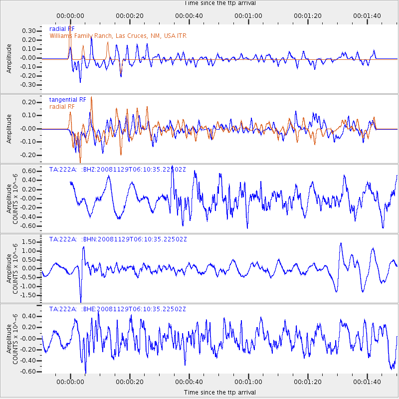
222A Williams Family Ranch, Las Cruces, NM, USA - Earthquake Result Viewer
*The percent match for this event was below the threshold and hence no stack was calculated.
| Earthquake location: |
Fiji Islands Region |
| Earthquake latitude/longitude: |
-18.7/-177.7 |
| Earthquake time(UTC): |
2008/11/29 (334) 05:59:16 GMT |
| Earthquake Depth: |
386 km |
| Earthquake Magnitude: |
5.7 MB, 6.0 MW, 5.9 MW |
| Earthquake Catalog/Contributor: |
WHDF/NEIC |
|
| Network: |
TA USArray Transportable Network (new EarthScope stations) |
| Station: |
222A Williams Family Ranch, Las Cruces, NM, USA |
| Lat/Lon: |
32.10 N/107.10 W |
| Elevation: |
1324 m |
|
| Distance: |
84.4 deg |
| Az: |
53.559 deg |
| Baz: |
243.959 deg |
| Ray Param: |
$rayparam |
*The percent match for this event was below the threshold and hence was not used in the summary stack. |
|
| Radial Match: |
53.82534 % |
| Radial Bump: |
400 |
| Transverse Match: |
66.084785 % |
| Transverse Bump: |
400 |
| SOD ConfigId: |
2658 |
| Insert Time: |
2010-03-06 12:58:50.299 +0000 |
| GWidth: |
2.5 |
| Max Bumps: |
400 |
| Tol: |
0.001 |
|
Signal To Noise
| Channel | StoN | STA | LTA |
| TA:222A: :BHN:20081129T06:10:35.22502Z | 3.504653 | 6.835181E-7 | 1.9503162E-7 |
| TA:222A: :BHE:20081129T06:10:35.22502Z | 0.84743184 | 2.2435813E-7 | 2.6475067E-7 |
| TA:222A: :BHZ:20081129T06:10:35.22502Z | 1.0571082 | 2.498681E-7 | 2.3636946E-7 |
| Arrivals |
| Ps | |
| PpPs | |
| PsPs/PpSs | |


