You are here: Home > Network List > NE - New England Seismic Network Stations List
> Station PQI Presque Isle, ME, USA > Earthquake Result Viewer
PQI Presque Isle, ME, USA - Earthquake Result Viewer
| Earthquake location: |
Off Coast Of Jalisco, Mexico |
| Earthquake latitude/longitude: |
18.4/-105.2 |
| Earthquake time(UTC): |
2016/06/07 (159) 10:51:38 GMT |
| Earthquake Depth: |
10 km |
| Earthquake Magnitude: |
6.2 MWP |
| Earthquake Catalog/Contributor: |
NEIC PDE/NEIC COMCAT |
|
| Network: |
NE New England Seismic Network |
| Station: |
PQI Presque Isle, ME, USA |
| Lat/Lon: |
46.67 N/68.02 W |
| Elevation: |
162 m |
|
| Distance: |
41.5 deg |
| Az: |
38.868 deg |
| Baz: |
239.907 deg |
| Ray Param: |
0.07373587 |
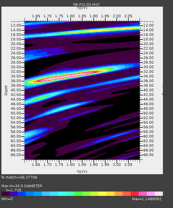
| Estimated Moho Depth: |
34.5 km |
| Estimated Crust Vp/Vs: |
1.74 |
| Assumed Crust Vp: |
6.419 km/s |
| Estimated Crust Vs: |
3.7 km/s |
| Estimated Crust Poisson's Ratio: |
0.25 |
|
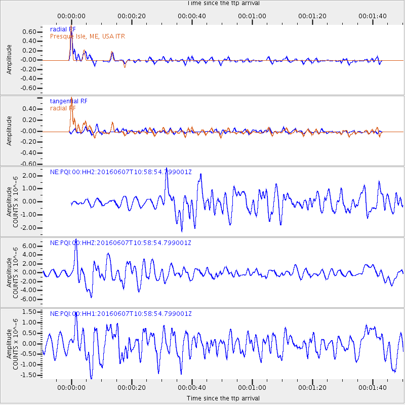
| Radial Match: |
86.37786 % |
| Radial Bump: |
400 |
| Transverse Match: |
74.28963 % |
| Transverse Bump: |
400 |
| SOD ConfigId: |
1609551 |
| Insert Time: |
2016-06-22 15:19:15.780 +0000 |
| GWidth: |
2.5 |
| Max Bumps: |
400 |
| Tol: |
0.001 |
|
Signal To Noise
| Channel | StoN | STA | LTA |
| NE:PQI:00:HHZ:20160607T10:58:54.799001Z | 8.565511 | 2.7161457E-6 | 3.1710258E-7 |
| NE:PQI:00:HH1:20160607T10:58:54.799001Z | 2.6072547 | 5.984303E-7 | 2.2952507E-7 |
| NE:PQI:00:HH2:20160607T10:58:54.799001Z | 4.0132804 | 9.944127E-7 | 2.4778055E-7 |
| Arrivals |
| Ps | 4.2 SECOND |
| PpPs | 14 SECOND |
| PsPs/PpSs | 18 SECOND |


