You are here: Home > Network List > TA - USArray Transportable Network (new EarthScope stations) Stations List
> Station 222A Williams Family Ranch, Las Cruces, NM, USA > Earthquake Result Viewer
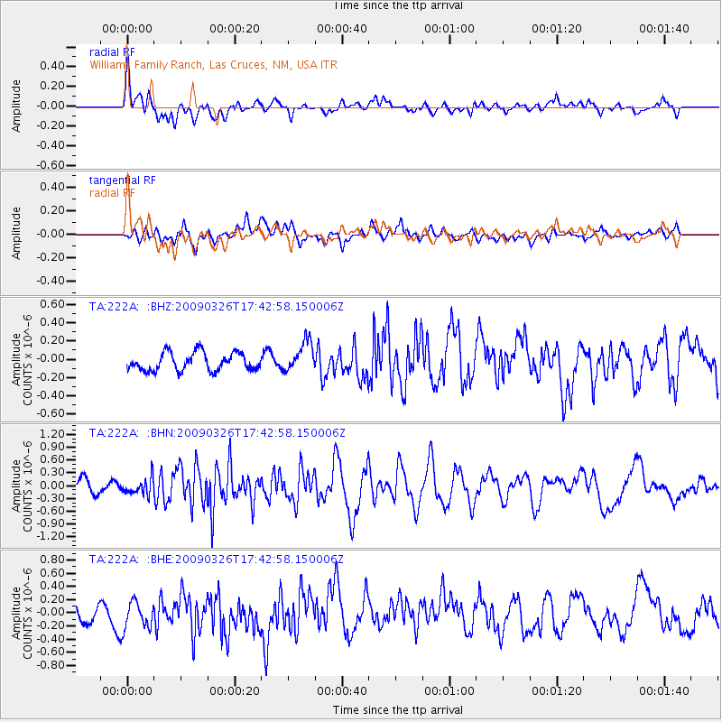
222A Williams Family Ranch, Las Cruces, NM, USA - Earthquake Result Viewer
*The percent match for this event was below the threshold and hence no stack was calculated.
| Earthquake location: |
Near Coast Of Northern Peru |
| Earthquake latitude/longitude: |
-5.7/-81.3 |
| Earthquake time(UTC): |
2009/03/26 (085) 17:35:14 GMT |
| Earthquake Depth: |
10 km |
| Earthquake Magnitude: |
5.6 MB, 5.5 MS, 5.8 MW, 5.7 MW |
| Earthquake Catalog/Contributor: |
WHDF/NEIC |
|
| Network: |
TA USArray Transportable Network (new EarthScope stations) |
| Station: |
222A Williams Family Ranch, Las Cruces, NM, USA |
| Lat/Lon: |
32.10 N/107.10 W |
| Elevation: |
1324 m |
|
| Distance: |
44.9 deg |
| Az: |
328.501 deg |
| Baz: |
142.221 deg |
| Ray Param: |
$rayparam |
*The percent match for this event was below the threshold and hence was not used in the summary stack. |
|
| Radial Match: |
54.76912 % |
| Radial Bump: |
400 |
| Transverse Match: |
55.80222 % |
| Transverse Bump: |
400 |
| SOD ConfigId: |
2658 |
| Insert Time: |
2010-03-06 12:59:12.557 +0000 |
| GWidth: |
2.5 |
| Max Bumps: |
400 |
| Tol: |
0.001 |
|
Signal To Noise
| Channel | StoN | STA | LTA |
| TA:222A: :BHN:20090326T17:42:58.150006Z | 1.141195 | 1.904259E-7 | 1.6686532E-7 |
| TA:222A: :BHE:20090326T17:42:58.150006Z | 1.4419602 | 2.0247408E-7 | 1.4041585E-7 |
| TA:222A: :BHZ:20090326T17:42:58.150006Z | 1.6698211 | 1.6371376E-7 | 9.80427E-8 |
| Arrivals |
| Ps | |
| PpPs | |
| PsPs/PpSs | |


