You are here: Home > Network List > TA - USArray Transportable Network (new EarthScope stations) Stations List
> Station B18K Kokolik River, AK, USA > Earthquake Result Viewer
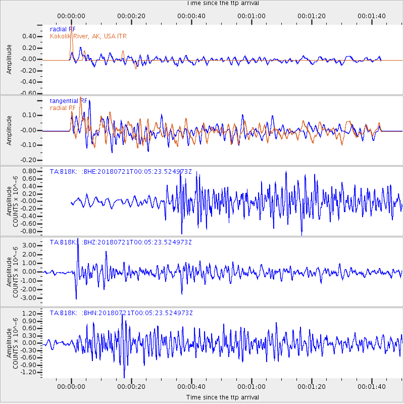
B18K Kokolik River, AK, USA - Earthquake Result Viewer
*The percent match for this event was below the threshold and hence no stack was calculated.
| Earthquake location: |
Mariana Islands |
| Earthquake latitude/longitude: |
18.5/146.0 |
| Earthquake time(UTC): |
2018/07/20 (201) 23:56:00 GMT |
| Earthquake Depth: |
126 km |
| Earthquake Magnitude: |
5.6 Mww |
| Earthquake Catalog/Contributor: |
NEIC PDE/us |
|
| Network: |
TA USArray Transportable Network (new EarthScope stations) |
| Station: |
B18K Kokolik River, AK, USA |
| Lat/Lon: |
69.36 N/161.80 W |
| Elevation: |
222 m |
|
| Distance: |
60.0 deg |
| Az: |
18.881 deg |
| Baz: |
240.039 deg |
| Ray Param: |
$rayparam |
*The percent match for this event was below the threshold and hence was not used in the summary stack. |
|
| Radial Match: |
80.30789 % |
| Radial Bump: |
400 |
| Transverse Match: |
76.39031 % |
| Transverse Bump: |
400 |
| SOD ConfigId: |
13570011 |
| Insert Time: |
2019-04-30 15:06:55.912 +0000 |
| GWidth: |
2.5 |
| Max Bumps: |
400 |
| Tol: |
0.001 |
|
Signal To Noise
| Channel | StoN | STA | LTA |
| TA:B18K: :BHZ:20180721T00:05:23.524973Z | 9.773463 | 1.1623719E-6 | 1.1893142E-7 |
| TA:B18K: :BHN:20180721T00:05:23.524973Z | 2.193595 | 1.9214339E-7 | 8.759292E-8 |
| TA:B18K: :BHE:20180721T00:05:23.524973Z | 2.301711 | 1.7649862E-7 | 7.668149E-8 |
| Arrivals |
| Ps | |
| PpPs | |
| PsPs/PpSs | |


