You are here: Home > Network List > TA - USArray Transportable Network (new EarthScope stations) Stations List
> Station E20K Nigu River, AK, USA > Earthquake Result Viewer
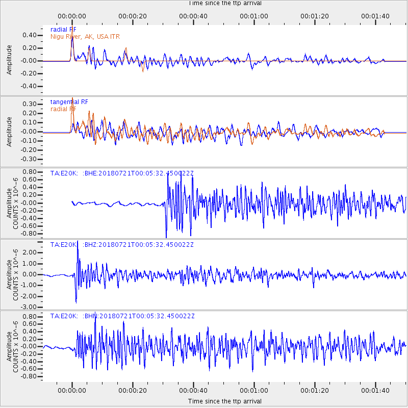
E20K Nigu River, AK, USA - Earthquake Result Viewer
*The percent match for this event was below the threshold and hence no stack was calculated.
| Earthquake location: |
Mariana Islands |
| Earthquake latitude/longitude: |
18.5/146.0 |
| Earthquake time(UTC): |
2018/07/20 (201) 23:56:00 GMT |
| Earthquake Depth: |
126 km |
| Earthquake Magnitude: |
5.6 Mww |
| Earthquake Catalog/Contributor: |
NEIC PDE/us |
|
| Network: |
TA USArray Transportable Network (new EarthScope stations) |
| Station: |
E20K Nigu River, AK, USA |
| Lat/Lon: |
68.26 N/156.19 W |
| Elevation: |
866 m |
|
| Distance: |
61.3 deg |
| Az: |
21.074 deg |
| Baz: |
246.346 deg |
| Ray Param: |
$rayparam |
*The percent match for this event was below the threshold and hence was not used in the summary stack. |
|
| Radial Match: |
74.86037 % |
| Radial Bump: |
400 |
| Transverse Match: |
80.461784 % |
| Transverse Bump: |
400 |
| SOD ConfigId: |
13570011 |
| Insert Time: |
2019-04-30 15:07:17.277 +0000 |
| GWidth: |
2.5 |
| Max Bumps: |
400 |
| Tol: |
0.001 |
|
Signal To Noise
| Channel | StoN | STA | LTA |
| TA:E20K: :BHZ:20180721T00:05:32.450022Z | 16.936785 | 9.776141E-7 | 5.7721355E-8 |
| TA:E20K: :BHN:20180721T00:05:32.450022Z | 5.2247686 | 2.1520864E-7 | 4.119008E-8 |
| TA:E20K: :BHE:20180721T00:05:32.450022Z | 11.213787 | 3.3043477E-7 | 2.9466833E-8 |
| Arrivals |
| Ps | |
| PpPs | |
| PsPs/PpSs | |


