You are here: Home > Network List > TA - USArray Transportable Network (new EarthScope stations) Stations List
> Station F26K Sheenjek River, AK, USA > Earthquake Result Viewer
F26K Sheenjek River, AK, USA - Earthquake Result Viewer
| Earthquake location: |
Mariana Islands |
| Earthquake latitude/longitude: |
18.5/146.0 |
| Earthquake time(UTC): |
2018/07/20 (201) 23:56:00 GMT |
| Earthquake Depth: |
126 km |
| Earthquake Magnitude: |
5.6 Mww |
| Earthquake Catalog/Contributor: |
NEIC PDE/us |
|
| Network: |
TA USArray Transportable Network (new EarthScope stations) |
| Station: |
F26K Sheenjek River, AK, USA |
| Lat/Lon: |
67.69 N/144.15 W |
| Elevation: |
683 m |
|
| Distance: |
65.4 deg |
| Az: |
23.208 deg |
| Baz: |
258.463 deg |
| Ray Param: |
0.057930253 |
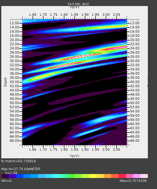
| Estimated Moho Depth: |
27.75 km |
| Estimated Crust Vp/Vs: |
1.88 |
| Assumed Crust Vp: |
6.522 km/s |
| Estimated Crust Vs: |
3.469 km/s |
| Estimated Crust Poisson's Ratio: |
0.30 |
|
| Radial Match: |
83.735916 % |
| Radial Bump: |
400 |
| Transverse Match: |
74.47008 % |
| Transverse Bump: |
400 |
| SOD ConfigId: |
13570011 |
| Insert Time: |
2019-04-30 15:07:31.556 +0000 |
| GWidth: |
2.5 |
| Max Bumps: |
400 |
| Tol: |
0.001 |
|
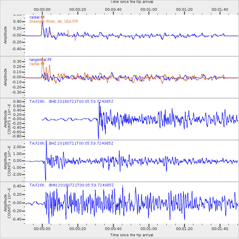
Signal To Noise
| Channel | StoN | STA | LTA |
| TA:F26K: :BHZ:20180721T00:05:59.724985Z | 22.515667 | 8.8006067E-7 | 3.908659E-8 |
| TA:F26K: :BHN:20180721T00:05:59.724985Z | 6.7325773 | 1.5651572E-7 | 2.3247521E-8 |
| TA:F26K: :BHE:20180721T00:05:59.724985Z | 9.299651 | 3.1009583E-7 | 3.334489E-8 |
| Arrivals |
| Ps | 3.9 SECOND |
| PpPs | 12 SECOND |
| PsPs/PpSs | 16 SECOND |


