You are here: Home > Network List > TA - USArray Transportable Network (new EarthScope stations) Stations List
> Station H24K Noodor Dome, AK, USA > Earthquake Result Viewer
H24K Noodor Dome, AK, USA - Earthquake Result Viewer
| Earthquake location: |
Mariana Islands |
| Earthquake latitude/longitude: |
18.5/146.0 |
| Earthquake time(UTC): |
2018/07/20 (201) 23:56:00 GMT |
| Earthquake Depth: |
126 km |
| Earthquake Magnitude: |
5.6 Mww |
| Earthquake Catalog/Contributor: |
NEIC PDE/us |
|
| Network: |
TA USArray Transportable Network (new EarthScope stations) |
| Station: |
H24K Noodor Dome, AK, USA |
| Lat/Lon: |
65.84 N/147.88 W |
| Elevation: |
814 m |
|
| Distance: |
63.6 deg |
| Az: |
24.856 deg |
| Baz: |
255.746 deg |
| Ray Param: |
0.059133656 |
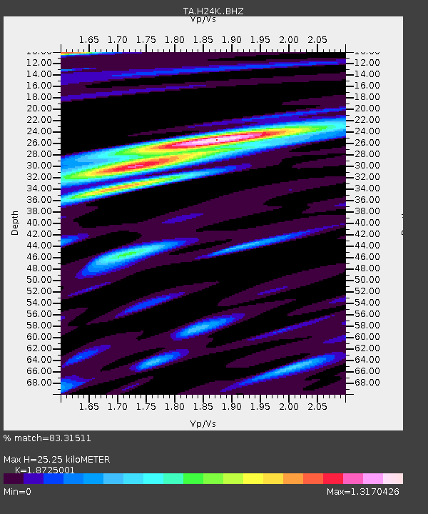
| Estimated Moho Depth: |
25.25 km |
| Estimated Crust Vp/Vs: |
1.87 |
| Assumed Crust Vp: |
6.566 km/s |
| Estimated Crust Vs: |
3.507 km/s |
| Estimated Crust Poisson's Ratio: |
0.30 |
|
| Radial Match: |
83.31511 % |
| Radial Bump: |
400 |
| Transverse Match: |
86.94569 % |
| Transverse Bump: |
400 |
| SOD ConfigId: |
13570011 |
| Insert Time: |
2019-04-30 15:07:53.673 +0000 |
| GWidth: |
2.5 |
| Max Bumps: |
400 |
| Tol: |
0.001 |
|
Signal To Noise
| Channel | StoN | STA | LTA |
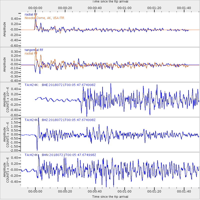
| TA:H24K: :BHZ:20180721T00:05:47.674998Z | 21.140018 | 7.708919E-7 | 3.6465998E-8 |
| TA:H24K: :BHN:20180721T00:05:47.674998Z | 6.744351 | 1.982507E-7 | 2.9395075E-8 |
| TA:H24K: :BHE:20180721T00:05:47.674998Z | 5.162099 | 2.3170081E-7 | 4.4885002E-8 |
| Arrivals |
| Ps | 3.5 SECOND |
| PpPs | 11 SECOND |
| PsPs/PpSs | 14 SECOND |


