You are here: Home > Network List > TA - USArray Transportable Network (new EarthScope stations) Stations List
> Station L15K Ungalak Mountain, AK, USA > Earthquake Result Viewer
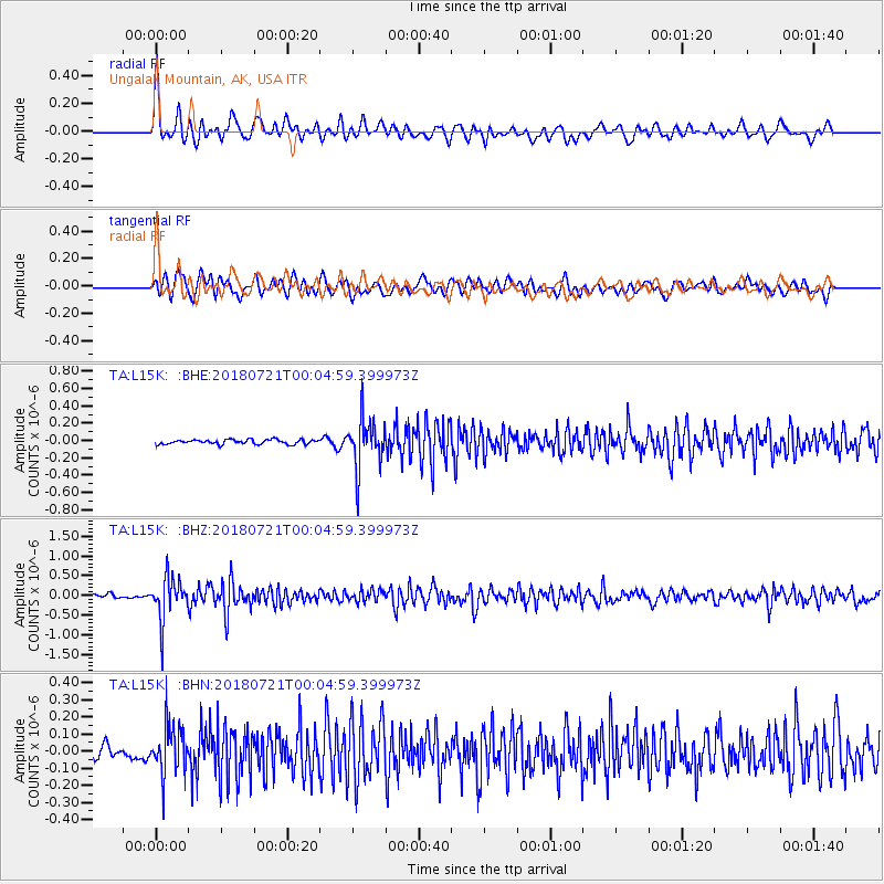
L15K Ungalak Mountain, AK, USA - Earthquake Result Viewer
*The percent match for this event was below the threshold and hence no stack was calculated.
| Earthquake location: |
Mariana Islands |
| Earthquake latitude/longitude: |
18.5/146.0 |
| Earthquake time(UTC): |
2018/07/20 (201) 23:56:00 GMT |
| Earthquake Depth: |
126 km |
| Earthquake Magnitude: |
5.6 Mww |
| Earthquake Catalog/Contributor: |
NEIC PDE/us |
|
| Network: |
TA USArray Transportable Network (new EarthScope stations) |
| Station: |
L15K Ungalak Mountain, AK, USA |
| Lat/Lon: |
61.68 N/161.49 W |
| Elevation: |
219 m |
|
| Distance: |
56.5 deg |
| Az: |
26.995 deg |
| Baz: |
244.607 deg |
| Ray Param: |
$rayparam |
*The percent match for this event was below the threshold and hence was not used in the summary stack. |
|
| Radial Match: |
78.07677 % |
| Radial Bump: |
400 |
| Transverse Match: |
72.49001 % |
| Transverse Bump: |
400 |
| SOD ConfigId: |
13570011 |
| Insert Time: |
2019-04-30 15:08:19.445 +0000 |
| GWidth: |
2.5 |
| Max Bumps: |
400 |
| Tol: |
0.001 |
|
Signal To Noise
| Channel | StoN | STA | LTA |
| TA:L15K: :BHZ:20180721T00:04:59.399973Z | 14.077941 | 5.421694E-7 | 3.851198E-8 |
| TA:L15K: :BHN:20180721T00:04:59.399973Z | 3.4950616 | 1.4393518E-7 | 4.1182446E-8 |
| TA:L15K: :BHE:20180721T00:04:59.399973Z | 10.6072 | 2.7830174E-7 | 2.623706E-8 |
| Arrivals |
| Ps | |
| PpPs | |
| PsPs/PpSs | |


