You are here: Home > Network List > TA - USArray Transportable Network (new EarthScope stations) Stations List
> Station O17K Koliganek, Bristol Bay, AK, USA > Earthquake Result Viewer
O17K Koliganek, Bristol Bay, AK, USA - Earthquake Result Viewer
| Earthquake location: |
Mariana Islands |
| Earthquake latitude/longitude: |
18.5/146.0 |
| Earthquake time(UTC): |
2018/07/20 (201) 23:56:00 GMT |
| Earthquake Depth: |
126 km |
| Earthquake Magnitude: |
5.6 Mww |
| Earthquake Catalog/Contributor: |
NEIC PDE/us |
|
| Network: |
TA USArray Transportable Network (new EarthScope stations) |
| Station: |
O17K Koliganek, Bristol Bay, AK, USA |
| Lat/Lon: |
59.77 N/157.09 W |
| Elevation: |
156 m |
|
| Distance: |
57.7 deg |
| Az: |
30.085 deg |
| Baz: |
250.111 deg |
| Ray Param: |
0.062917545 |
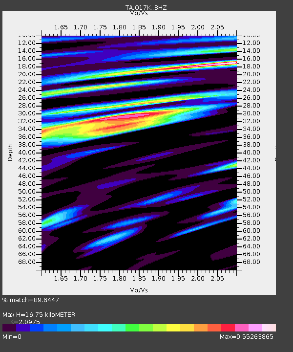
| Estimated Moho Depth: |
16.75 km |
| Estimated Crust Vp/Vs: |
2.10 |
| Assumed Crust Vp: |
6.276 km/s |
| Estimated Crust Vs: |
2.992 km/s |
| Estimated Crust Poisson's Ratio: |
0.35 |
|
| Radial Match: |
89.6447 % |
| Radial Bump: |
400 |
| Transverse Match: |
74.50849 % |
| Transverse Bump: |
400 |
| SOD ConfigId: |
13570011 |
| Insert Time: |
2019-04-30 15:08:52.271 +0000 |
| GWidth: |
2.5 |
| Max Bumps: |
400 |
| Tol: |
0.001 |
|
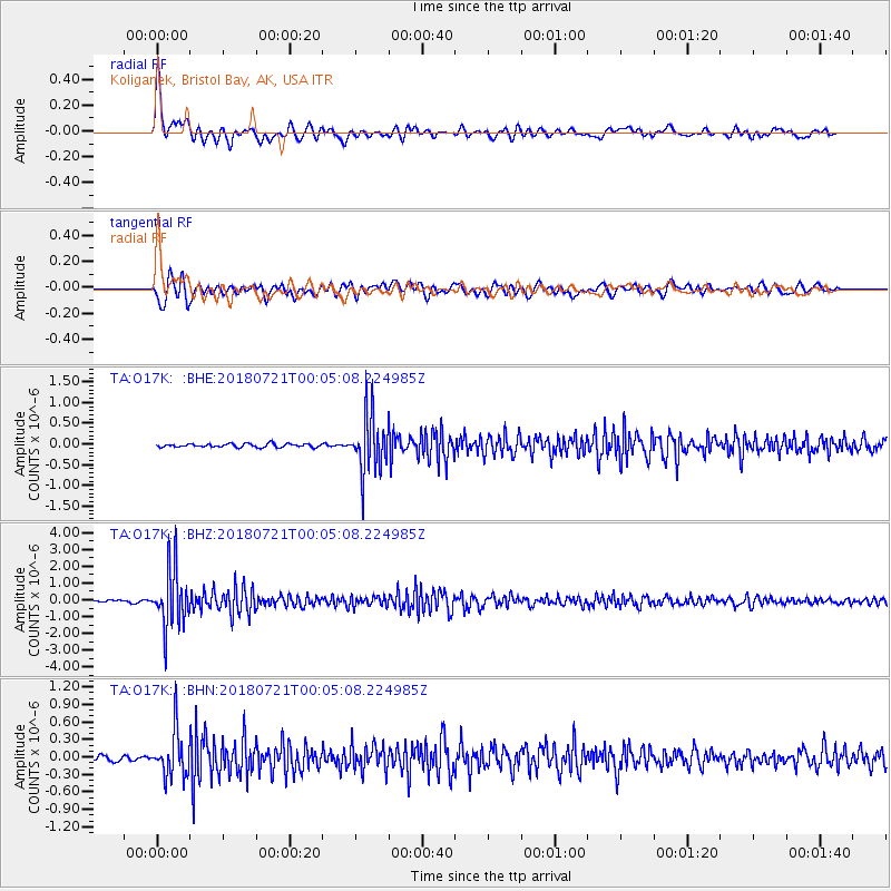
Signal To Noise
| Channel | StoN | STA | LTA |
| TA:O17K: :BHZ:20180721T00:05:08.224985Z | 32.997475 | 1.7088851E-6 | 5.178836E-8 |
| TA:O17K: :BHN:20180721T00:05:08.224985Z | 7.224236 | 3.850673E-7 | 5.330215E-8 |
| TA:O17K: :BHE:20180721T00:05:08.224985Z | 16.528017 | 7.076041E-7 | 4.28124E-8 |
| Arrivals |
| Ps | 3.0 SECOND |
| PpPs | 8.0 SECOND |
| PsPs/PpSs | 11 SECOND |


