You are here: Home > Network List > TA - USArray Transportable Network (new EarthScope stations) Stations List
> Station O18K Koktuh Hills, AK, USA > Earthquake Result Viewer
O18K Koktuh Hills, AK, USA - Earthquake Result Viewer
| Earthquake location: |
Mariana Islands |
| Earthquake latitude/longitude: |
18.5/146.0 |
| Earthquake time(UTC): |
2018/07/20 (201) 23:56:00 GMT |
| Earthquake Depth: |
126 km |
| Earthquake Magnitude: |
5.6 Mww |
| Earthquake Catalog/Contributor: |
NEIC PDE/us |
|
| Network: |
TA USArray Transportable Network (new EarthScope stations) |
| Station: |
O18K Koktuh Hills, AK, USA |
| Lat/Lon: |
59.85 N/155.21 W |
| Elevation: |
544 m |
|
| Distance: |
58.7 deg |
| Az: |
30.359 deg |
| Baz: |
251.884 deg |
| Ray Param: |
0.062315345 |
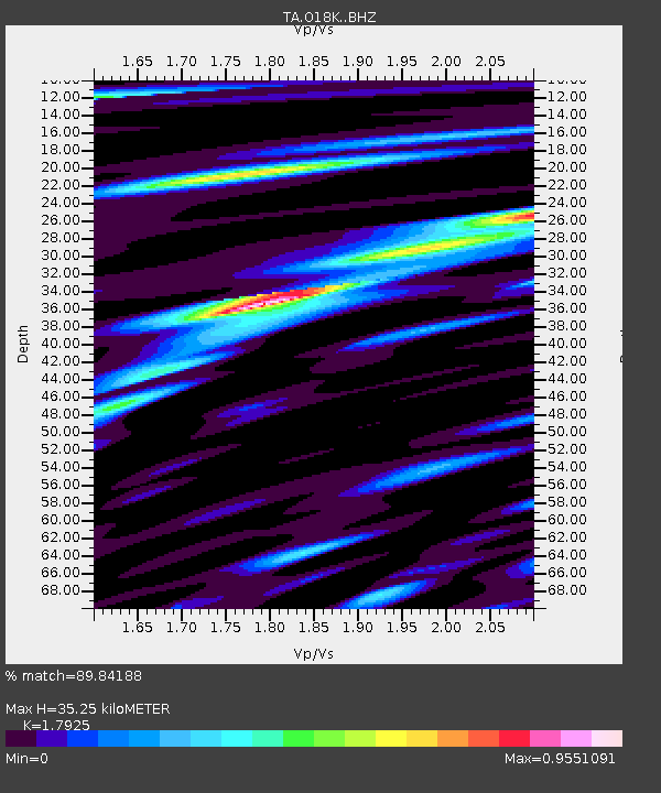
| Estimated Moho Depth: |
35.25 km |
| Estimated Crust Vp/Vs: |
1.79 |
| Assumed Crust Vp: |
6.438 km/s |
| Estimated Crust Vs: |
3.592 km/s |
| Estimated Crust Poisson's Ratio: |
0.27 |
|
| Radial Match: |
89.84188 % |
| Radial Bump: |
400 |
| Transverse Match: |
88.12581 % |
| Transverse Bump: |
400 |
| SOD ConfigId: |
13570011 |
| Insert Time: |
2019-04-30 15:08:52.526 +0000 |
| GWidth: |
2.5 |
| Max Bumps: |
400 |
| Tol: |
0.001 |
|

Signal To Noise
| Channel | StoN | STA | LTA |
| TA:O18K: :BHZ:20180721T00:05:14.649973Z | 34.20006 | 1.7058021E-6 | 4.9877166E-8 |
| TA:O18K: :BHN:20180721T00:05:14.649973Z | 8.563398 | 5.3059705E-7 | 6.196104E-8 |
| TA:O18K: :BHE:20180721T00:05:14.649973Z | 10.671996 | 6.1811227E-7 | 5.7919088E-8 |
| Arrivals |
| Ps | 4.5 SECOND |
| PpPs | 15 SECOND |
| PsPs/PpSs | 19 SECOND |


