You are here: Home > Network List > TA - USArray Transportable Network (new EarthScope stations) Stations List
> Station 626A Big Bend Ranch, Presidio, TX, USA > Earthquake Result Viewer
626A Big Bend Ranch, Presidio, TX, USA - Earthquake Result Viewer
| Earthquake location: |
Vanuatu Islands |
| Earthquake latitude/longitude: |
-13.5/167.0 |
| Earthquake time(UTC): |
2008/09/08 (252) 18:52:06 GMT |
| Earthquake Depth: |
110 km |
| Earthquake Magnitude: |
6.4 MB, 6.9 MW, 6.9 MW |
| Earthquake Catalog/Contributor: |
WHDF/NEIC |
|
| Network: |
TA USArray Transportable Network (new EarthScope stations) |
| Station: |
626A Big Bend Ranch, Presidio, TX, USA |
| Lat/Lon: |
29.55 N/104.13 W |
| Elevation: |
979 m |
|
| Distance: |
95.6 deg |
| Az: |
61.083 deg |
| Baz: |
257.742 deg |
| Ray Param: |
0.040660325 |
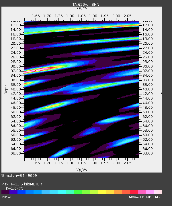
| Estimated Moho Depth: |
31.5 km |
| Estimated Crust Vp/Vs: |
1.65 |
| Assumed Crust Vp: |
6.279 km/s |
| Estimated Crust Vs: |
3.811 km/s |
| Estimated Crust Poisson's Ratio: |
0.21 |
|
| Radial Match: |
84.49909 % |
| Radial Bump: |
400 |
| Transverse Match: |
84.62649 % |
| Transverse Bump: |
400 |
| SOD ConfigId: |
2560 |
| Insert Time: |
2010-03-06 13:00:24.134 +0000 |
| GWidth: |
2.5 |
| Max Bumps: |
400 |
| Tol: |
0.001 |
|
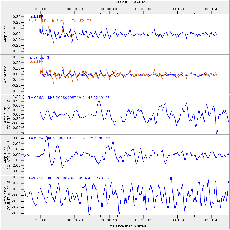
Signal To Noise
| Channel | StoN | STA | LTA |
| TA:626A: :BHN:20080908T19:04:48.524016Z | 12.234754 | 1.8336443E-6 | 1.4987178E-7 |
| TA:626A: :BHE:20080908T19:04:48.524016Z | 1.0946431 | 8.139781E-8 | 7.436014E-8 |
| TA:626A: :BHZ:20080908T19:04:48.524016Z | 2.6430326 | 4.7965506E-7 | 1.8147907E-7 |
| Arrivals |
| Ps | 3.3 SECOND |
| PpPs | 13 SECOND |
| PsPs/PpSs | 16 SECOND |


