You are here: Home > Network List > TA - USArray Transportable Network (new EarthScope stations) Stations List
> Station 626A Big Bend Ranch, Presidio, TX, USA > Earthquake Result Viewer
626A Big Bend Ranch, Presidio, TX, USA - Earthquake Result Viewer
| Earthquake location: |
Andreanof Islands, Aleutian Is. |
| Earthquake latitude/longitude: |
52.2/-178.7 |
| Earthquake time(UTC): |
2008/03/22 (082) 21:24:11 GMT |
| Earthquake Depth: |
132 km |
| Earthquake Magnitude: |
5.8 MB, 6.2 MW, 6.1 MW |
| Earthquake Catalog/Contributor: |
WHDF/NEIC |
|
| Network: |
TA USArray Transportable Network (new EarthScope stations) |
| Station: |
626A Big Bend Ranch, Presidio, TX, USA |
| Lat/Lon: |
29.55 N/104.13 W |
| Elevation: |
979 m |
|
| Distance: |
58.0 deg |
| Az: |
81.89 deg |
| Baz: |
315.598 deg |
| Ray Param: |
0.06269705 |
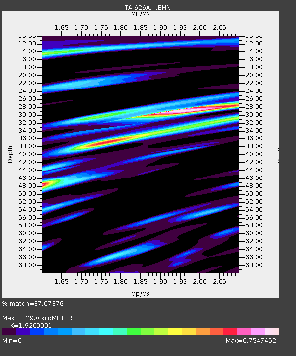
| Estimated Moho Depth: |
29.0 km |
| Estimated Crust Vp/Vs: |
1.92 |
| Assumed Crust Vp: |
6.279 km/s |
| Estimated Crust Vs: |
3.27 km/s |
| Estimated Crust Poisson's Ratio: |
0.31 |
|
| Radial Match: |
87.07376 % |
| Radial Bump: |
400 |
| Transverse Match: |
74.62182 % |
| Transverse Bump: |
400 |
| SOD ConfigId: |
2564 |
| Insert Time: |
2010-03-06 13:00:29.359 +0000 |
| GWidth: |
2.5 |
| Max Bumps: |
400 |
| Tol: |
0.001 |
|

Signal To Noise
| Channel | StoN | STA | LTA |
| TA:626A: :BHN:20080322T21:33:19.775005Z | 9.851831 | 5.624234E-7 | 5.7088208E-8 |
| TA:626A: :BHE:20080322T21:33:19.775005Z | 3.3168354 | 7.990226E-7 | 2.4089906E-7 |
| TA:626A: :BHZ:20080322T21:33:19.775005Z | 9.749247 | 2.6307632E-6 | 2.698427E-7 |
| Arrivals |
| Ps | 4.4 SECOND |
| PpPs | 13 SECOND |
| PsPs/PpSs | 17 SECOND |


