You are here: Home > Network List > TA - USArray Transportable Network (new EarthScope stations) Stations List
> Station Q20K Shuyak Island, AK, USA > Earthquake Result Viewer
Q20K Shuyak Island, AK, USA - Earthquake Result Viewer
| Earthquake location: |
Mariana Islands |
| Earthquake latitude/longitude: |
18.5/146.0 |
| Earthquake time(UTC): |
2018/07/20 (201) 23:56:00 GMT |
| Earthquake Depth: |
126 km |
| Earthquake Magnitude: |
5.6 Mww |
| Earthquake Catalog/Contributor: |
NEIC PDE/us |
|
| Network: |
TA USArray Transportable Network (new EarthScope stations) |
| Station: |
Q20K Shuyak Island, AK, USA |
| Lat/Lon: |
58.61 N/152.39 W |
| Elevation: |
180 m |
|
| Distance: |
59.7 deg |
| Az: |
32.23 deg |
| Baz: |
255.256 deg |
| Ray Param: |
0.061641924 |
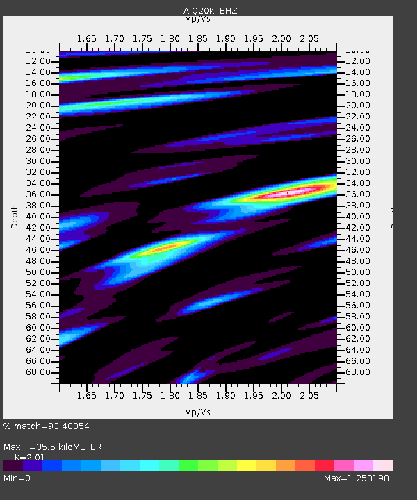
| Estimated Moho Depth: |
35.5 km |
| Estimated Crust Vp/Vs: |
2.01 |
| Assumed Crust Vp: |
5.989 km/s |
| Estimated Crust Vs: |
2.98 km/s |
| Estimated Crust Poisson's Ratio: |
0.34 |
|
| Radial Match: |
93.48054 % |
| Radial Bump: |
400 |
| Transverse Match: |
85.665085 % |
| Transverse Bump: |
400 |
| SOD ConfigId: |
13570011 |
| Insert Time: |
2019-04-30 15:09:08.917 +0000 |
| GWidth: |
2.5 |
| Max Bumps: |
400 |
| Tol: |
0.001 |
|

Signal To Noise
| Channel | StoN | STA | LTA |
| TA:Q20K: :BHZ:20180721T00:05:21.774973Z | 21.97078 | 1.9221136E-6 | 8.7485E-8 |
| TA:Q20K: :BHN:20180721T00:05:21.774973Z | 6.9092274 | 4.4284315E-7 | 6.409445E-8 |
| TA:Q20K: :BHE:20180721T00:05:21.774973Z | 24.077812 | 1.2923689E-6 | 5.3674686E-8 |
| Arrivals |
| Ps | 6.2 SECOND |
| PpPs | 17 SECOND |
| PsPs/PpSs | 23 SECOND |


