You are here: Home > Network List > TA - USArray Transportable Network (new EarthScope stations) Stations List
> Station R32K Eaglecrest, AK, USA > Earthquake Result Viewer
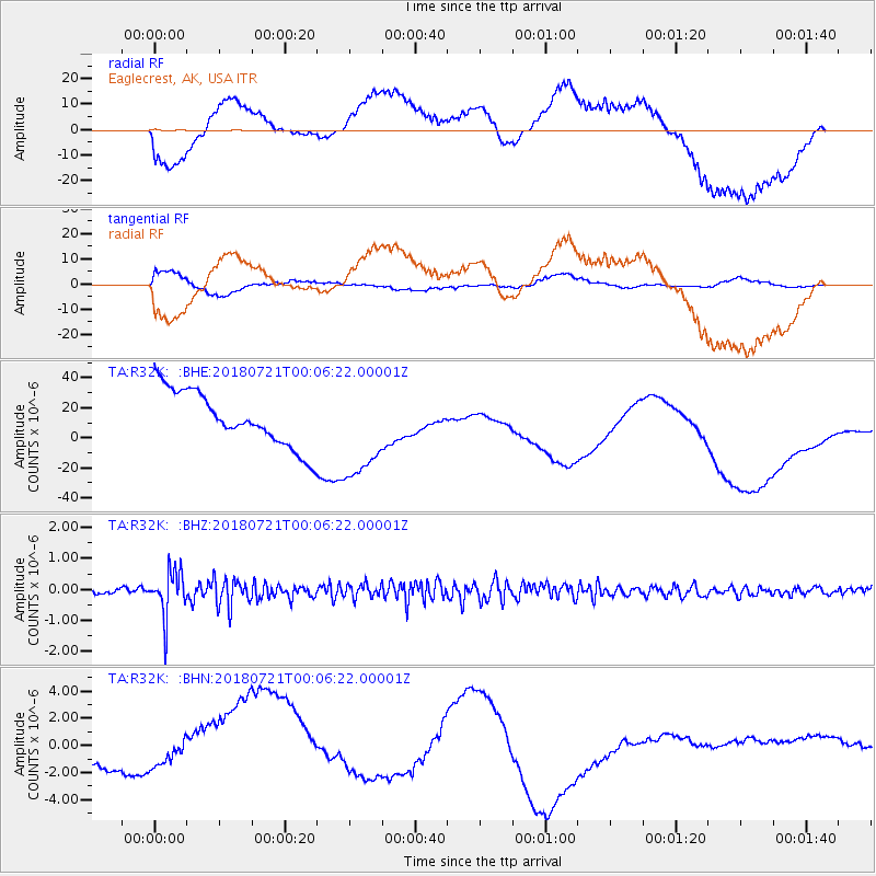
R32K Eaglecrest, AK, USA - Earthquake Result Viewer
*The percent match for this event was below the threshold and hence no stack was calculated.
| Earthquake location: |
Mariana Islands |
| Earthquake latitude/longitude: |
18.5/146.0 |
| Earthquake time(UTC): |
2018/07/20 (201) 23:56:00 GMT |
| Earthquake Depth: |
126 km |
| Earthquake Magnitude: |
5.6 Mww |
| Earthquake Catalog/Contributor: |
NEIC PDE/us |
|
| Network: |
TA USArray Transportable Network (new EarthScope stations) |
| Station: |
R32K Eaglecrest, AK, USA |
| Lat/Lon: |
58.27 N/134.52 W |
| Elevation: |
386 m |
|
| Distance: |
69.0 deg |
| Az: |
33.822 deg |
| Baz: |
271.187 deg |
| Ray Param: |
$rayparam |
*The percent match for this event was below the threshold and hence was not used in the summary stack. |
|
| Radial Match: |
59.92567 % |
| Radial Bump: |
400 |
| Transverse Match: |
56.260803 % |
| Transverse Bump: |
400 |
| SOD ConfigId: |
13570011 |
| Insert Time: |
2019-04-30 15:09:13.883 +0000 |
| GWidth: |
2.5 |
| Max Bumps: |
400 |
| Tol: |
0.001 |
|
Signal To Noise
| Channel | StoN | STA | LTA |
| TA:R32K: :BHZ:20180721T00:06:22.00001Z | 6.528362 | 7.2531117E-7 | 1.11101556E-7 |
| TA:R32K: :BHN:20180721T00:06:22.00001Z | 0.5777907 | 2.4615722E-6 | 4.2603183E-6 |
| TA:R32K: :BHE:20180721T00:06:22.00001Z | 1.837505 | 3.3031876E-5 | 1.7976483E-5 |
| Arrivals |
| Ps | |
| PpPs | |
| PsPs/PpSs | |


