You are here: Home > Network List > TA - USArray Transportable Network (new EarthScope stations) Stations List
> Station 626A Big Bend Ranch, Presidio, TX, USA > Earthquake Result Viewer
626A Big Bend Ranch, Presidio, TX, USA - Earthquake Result Viewer
| Earthquake location: |
Southern Peru |
| Earthquake latitude/longitude: |
-15.1/-70.2 |
| Earthquake time(UTC): |
2009/09/05 (248) 03:58:39 GMT |
| Earthquake Depth: |
210 km |
| Earthquake Magnitude: |
5.8 MW, 5.2 MB, 5.8 MW |
| Earthquake Catalog/Contributor: |
WHDF/NEIC |
|
| Network: |
TA USArray Transportable Network (new EarthScope stations) |
| Station: |
626A Big Bend Ranch, Presidio, TX, USA |
| Lat/Lon: |
29.55 N/104.13 W |
| Elevation: |
979 m |
|
| Distance: |
55.2 deg |
| Az: |
323.706 deg |
| Baz: |
138.995 deg |
| Ray Param: |
0.064257056 |
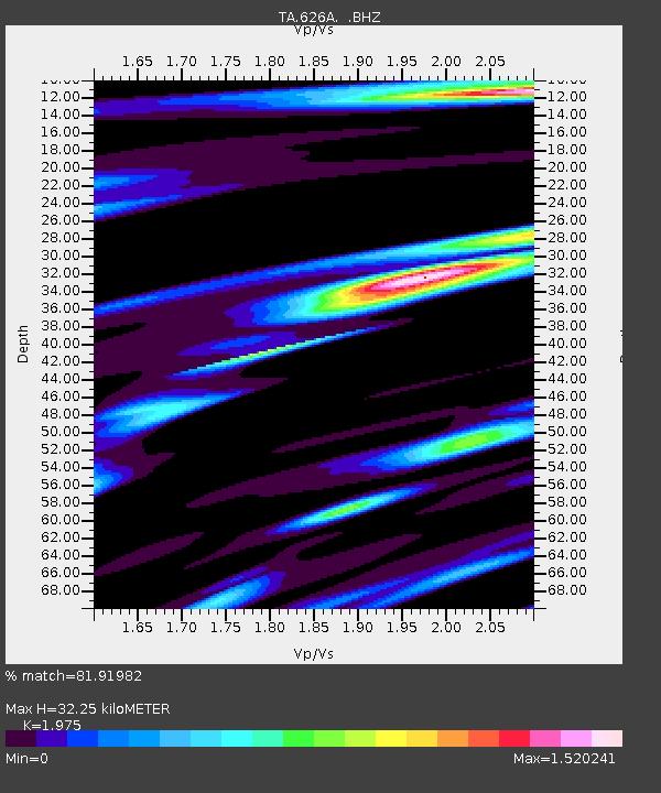
| Estimated Moho Depth: |
32.25 km |
| Estimated Crust Vp/Vs: |
1.98 |
| Assumed Crust Vp: |
6.279 km/s |
| Estimated Crust Vs: |
3.179 km/s |
| Estimated Crust Poisson's Ratio: |
0.33 |
|
| Radial Match: |
81.91982 % |
| Radial Bump: |
400 |
| Transverse Match: |
66.699936 % |
| Transverse Bump: |
400 |
| SOD ConfigId: |
2622 |
| Insert Time: |
2010-03-06 13:00:46.233 +0000 |
| GWidth: |
2.5 |
| Max Bumps: |
400 |
| Tol: |
0.001 |
|

Signal To Noise
| Channel | StoN | STA | LTA |
| TA:626A: :BHZ:20090905T04:07:19.324014Z | 3.428577 | 4.7505222E-7 | 1.3855667E-7 |
| TA:626A: :BHN:20090905T04:07:19.324014Z | 2.0021143 | 1.7512248E-7 | 8.746877E-8 |
| TA:626A: :BHE:20090905T04:07:19.324014Z | 2.5526216 | 1.7111886E-7 | 6.703651E-8 |
| Arrivals |
| Ps | 5.2 SECOND |
| PpPs | 15 SECOND |
| PsPs/PpSs | 20 SECOND |


