You are here: Home > Network List > TA - USArray Transportable Network (new EarthScope stations) Stations List
> Station 626A Big Bend Ranch, Presidio, TX, USA > Earthquake Result Viewer
626A Big Bend Ranch, Presidio, TX, USA - Earthquake Result Viewer
| Earthquake location: |
Kuril Islands |
| Earthquake latitude/longitude: |
46.0/151.4 |
| Earthquake time(UTC): |
2009/04/18 (108) 19:17:58 GMT |
| Earthquake Depth: |
35 km |
| Earthquake Magnitude: |
6.3 MB, 6.3 MS, 6.6 MW, 6.4 MW |
| Earthquake Catalog/Contributor: |
WHDF/NEIC |
|
| Network: |
TA USArray Transportable Network (new EarthScope stations) |
| Station: |
626A Big Bend Ranch, Presidio, TX, USA |
| Lat/Lon: |
29.55 N/104.13 W |
| Elevation: |
979 m |
|
| Distance: |
78.4 deg |
| Az: |
59.461 deg |
| Baz: |
316.46 deg |
| Ray Param: |
0.049595978 |
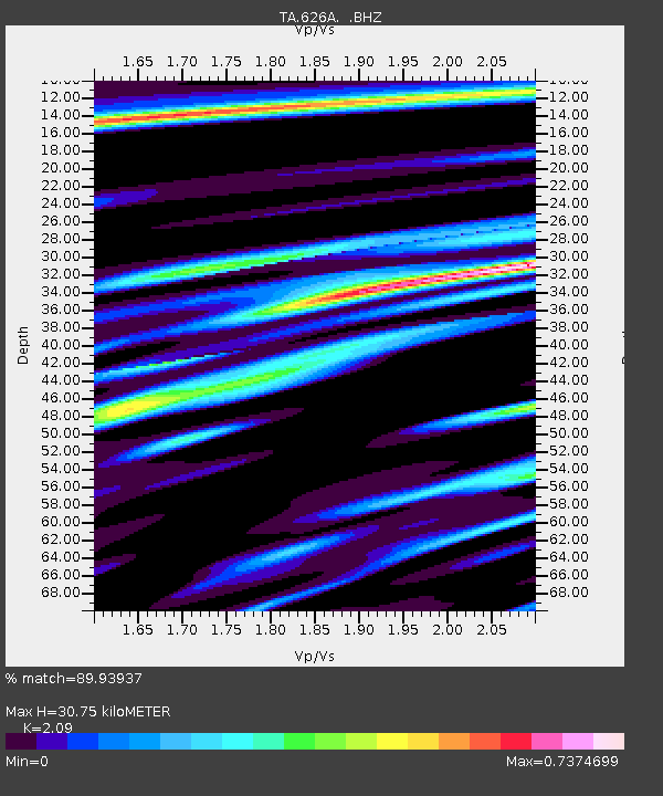
| Estimated Moho Depth: |
30.75 km |
| Estimated Crust Vp/Vs: |
2.09 |
| Assumed Crust Vp: |
6.279 km/s |
| Estimated Crust Vs: |
3.004 km/s |
| Estimated Crust Poisson's Ratio: |
0.35 |
|
| Radial Match: |
89.93937 % |
| Radial Bump: |
400 |
| Transverse Match: |
78.16878 % |
| Transverse Bump: |
400 |
| SOD ConfigId: |
2658 |
| Insert Time: |
2010-03-06 13:01:07.307 +0000 |
| GWidth: |
2.5 |
| Max Bumps: |
400 |
| Tol: |
0.001 |
|
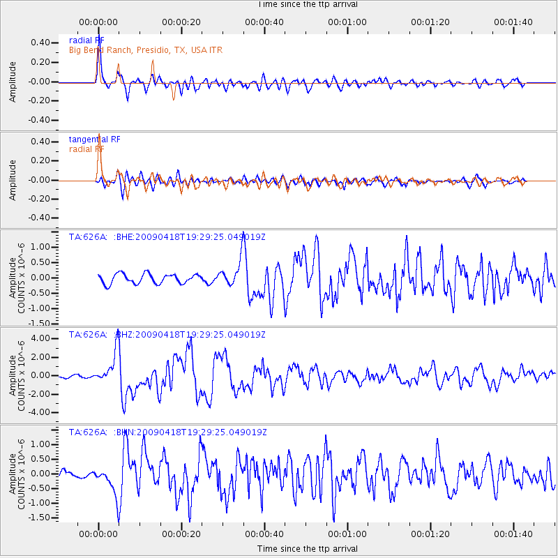
Signal To Noise
| Channel | StoN | STA | LTA |
| TA:626A: :BHZ:20090418T19:29:25.049019Z | 16.28278 | 1.906353E-6 | 1.1707786E-7 |
| TA:626A: :BHN:20090418T19:29:25.049019Z | 3.726862 | 5.0128807E-7 | 1.3450675E-7 |
| TA:626A: :BHE:20090418T19:29:25.049019Z | 2.890595 | 4.5343103E-7 | 1.5686426E-7 |
| Arrivals |
| Ps | 5.5 SECOND |
| PpPs | 15 SECOND |
| PsPs/PpSs | 20 SECOND |


