You are here: Home > Network List > G - GEOSCOPE Stations List
> Station INU Inuyama, Japan > Earthquake Result Viewer
INU Inuyama, Japan - Earthquake Result Viewer
| Earthquake location: |
Northern Molucca Sea |
| Earthquake latitude/longitude: |
1.3/126.3 |
| Earthquake time(UTC): |
2016/06/07 (159) 19:15:15 GMT |
| Earthquake Depth: |
31 km |
| Earthquake Magnitude: |
6.3 MWW, 6.2 MWB, 6.3 MWC, 6.4 MWC, 6.5 MI, 6.6 MI |
| Earthquake Catalog/Contributor: |
NEIC PDE/NEIC COMCAT |
|
| Network: |
G GEOSCOPE |
| Station: |
INU Inuyama, Japan |
| Lat/Lon: |
35.35 N/137.03 E |
| Elevation: |
132 m |
|
| Distance: |
35.3 deg |
| Az: |
15.223 deg |
| Baz: |
198.731 deg |
| Ray Param: |
0.077244766 |
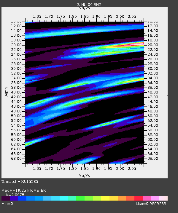
| Estimated Moho Depth: |
19.25 km |
| Estimated Crust Vp/Vs: |
2.10 |
| Assumed Crust Vp: |
6.461 km/s |
| Estimated Crust Vs: |
3.081 km/s |
| Estimated Crust Poisson's Ratio: |
0.35 |
|
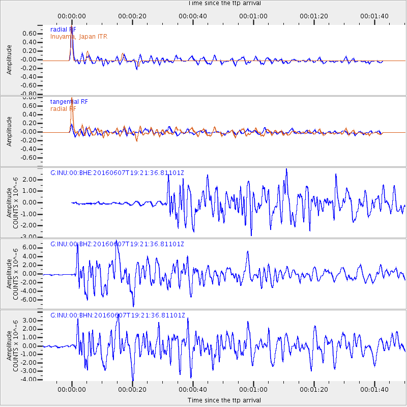
| Radial Match: |
92.15585 % |
| Radial Bump: |
400 |
| Transverse Match: |
81.2773 % |
| Transverse Bump: |
400 |
| SOD ConfigId: |
1609551 |
| Insert Time: |
2016-06-22 15:24:04.380 +0000 |
| GWidth: |
2.5 |
| Max Bumps: |
400 |
| Tol: |
0.001 |
|
Signal To Noise
| Channel | StoN | STA | LTA |
| G:INU:00:BHZ:20160607T19:21:36.81101Z | 38.597515 | 2.5474362E-6 | 6.6000005E-8 |
| G:INU:00:BHN:20160607T19:21:36.81101Z | 16.02702 | 1.2139036E-6 | 7.574106E-8 |
| G:INU:00:BHE:20160607T19:21:36.81101Z | 11.136605 | 8.3371293E-7 | 7.486239E-8 |
| Arrivals |
| Ps | 3.5 SECOND |
| PpPs | 8.7 SECOND |
| PsPs/PpSs | 12 SECOND |


