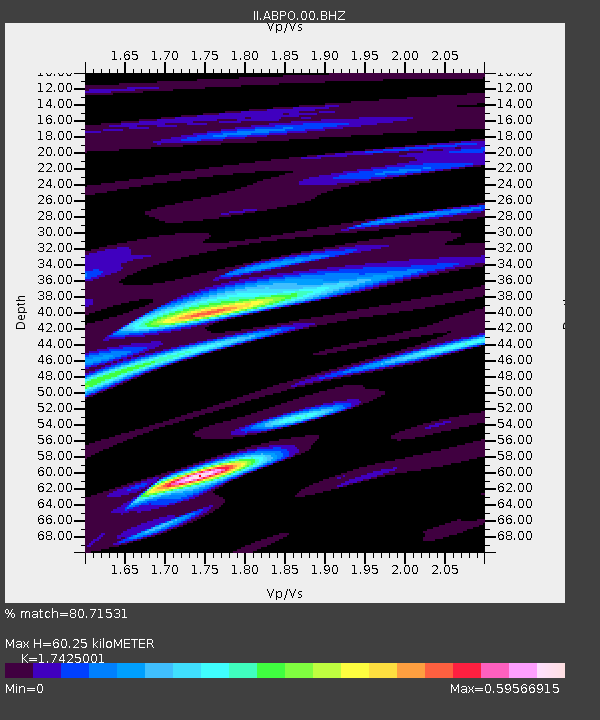
ABPO Ambohimpanompo, Madagascar - Earthquake Result Viewer
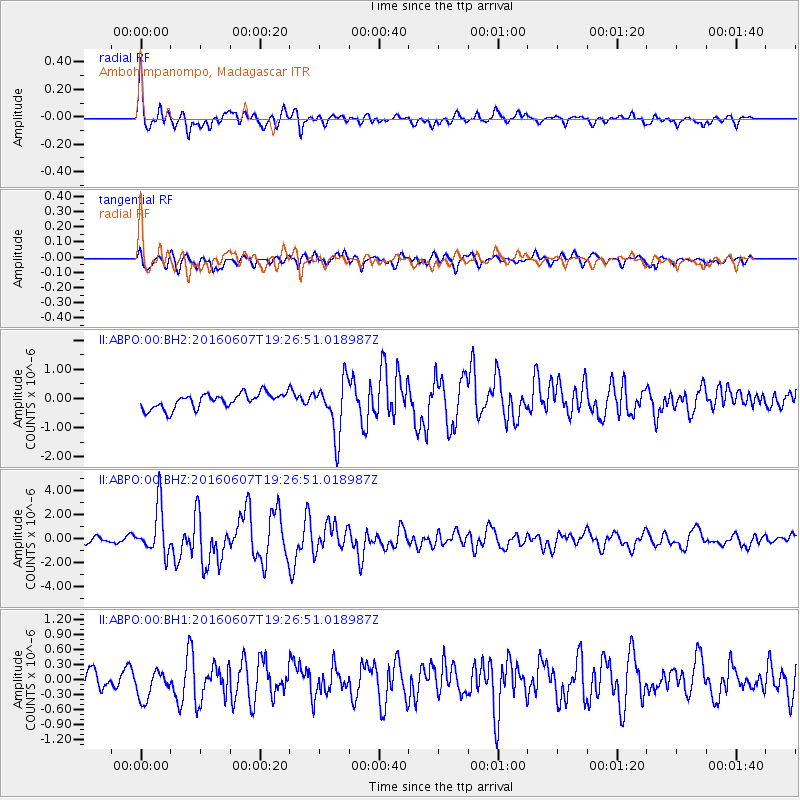
Earthquake location: Northern Molucca Sea
Earthquake latitude/longitude: 1.3/126.3
Earthquake time(UTC): 2016/06/07 (159) 19:15:15 GMT
Earthquake Depth: 31 km
Earthquake Magnitude: 6.3 MWW, 6.2 MWB, 6.3 MWC, 6.4 MWC, 6.5 MI, 6.6 MI
Earthquake Catalog/Contributor: NEIC PDE/NEIC COMCAT
Network: II Global Seismograph Network (GSN - IRIS/IDA)
Station: ABPO Ambohimpanompo, Madagascar
Lat/Lon: 19.02 S/47.23 E
Elevation: 1528 m
Distance: 80.1 deg
Az: 250.559 deg
Baz: 85.181 deg
Ray Param: 0.0484468
Estimated Moho Depth: 60.25 km
Estimated Crust Vp/Vs: 1.74
Assumed Crust Vp: 6.642 km/s
Estimated Crust Vs: 3.812 km/s
Estimated Crust Poisson's Ratio: 0.25
Radial Match: 80.71531 %
Radial Bump: 400
Transverse Match: 63.46694 %
Transverse Bump: 400
SOD ConfigId: 1609551
Insert Time: 2016-06-22 15:24:27.481 +0000
GWidth: 2.5
Max Bumps: 400
Tol: 0.001

Signal To Noise

ChannelStoNSTALTA
II:ABPO:00:BHZ:20160607T19:26:51.018987Z6.31613161.9723373E-63.1226983E-7
II:ABPO:00:BH1:20160607T19:26:51.018987Z0.928854642.9899766E-73.218993E-7
II:ABPO:00:BH2:20160607T19:26:51.018987Z3.6051519.232251E-72.56085E-7
Arrivals
Ps6.9 SECOND
PpPs24 SECOND
PsPs/PpSs31 SECOND