You are here: Home > Network List > TA - USArray Transportable Network (new EarthScope stations) Stations List
> Station E27K Coleen River, AK, USA > Earthquake Result Viewer
E27K Coleen River, AK, USA - Earthquake Result Viewer
| Earthquake location: |
Western Iran |
| Earthquake latitude/longitude: |
34.6/46.2 |
| Earthquake time(UTC): |
2018/07/22 (203) 10:07:27 GMT |
| Earthquake Depth: |
12 km |
| Earthquake Magnitude: |
5.8 Mww |
| Earthquake Catalog/Contributor: |
NEIC PDE/us |
|
| Network: |
TA USArray Transportable Network (new EarthScope stations) |
| Station: |
E27K Coleen River, AK, USA |
| Lat/Lon: |
68.19 N/141.60 W |
| Elevation: |
654 m |
|
| Distance: |
77.4 deg |
| Az: |
2.965 deg |
| Baz: |
353.444 deg |
| Ray Param: |
0.05036563 |
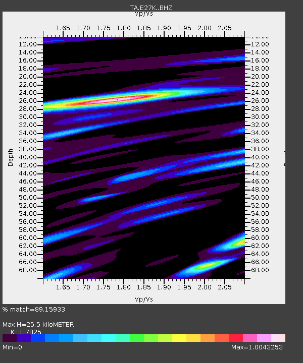
| Estimated Moho Depth: |
25.5 km |
| Estimated Crust Vp/Vs: |
1.78 |
| Assumed Crust Vp: |
6.522 km/s |
| Estimated Crust Vs: |
3.659 km/s |
| Estimated Crust Poisson's Ratio: |
0.27 |
|
| Radial Match: |
89.15933 % |
| Radial Bump: |
385 |
| Transverse Match: |
84.35664 % |
| Transverse Bump: |
400 |
| SOD ConfigId: |
13570011 |
| Insert Time: |
2019-04-30 15:22:37.595 +0000 |
| GWidth: |
2.5 |
| Max Bumps: |
400 |
| Tol: |
0.001 |
|

Signal To Noise
| Channel | StoN | STA | LTA |
| TA:E27K: :BHZ:20180722T10:18:50.50002Z | 10.7595 | 4.514302E-7 | 4.195643E-8 |
| TA:E27K: :BHN:20180722T10:18:50.50002Z | 3.950693 | 1.5800282E-7 | 3.9993697E-8 |
| TA:E27K: :BHE:20180722T10:18:50.50002Z | 1.4433633 | 5.3770496E-8 | 3.7253614E-8 |
| Arrivals |
| Ps | 3.2 SECOND |
| PpPs | 11 SECOND |
| PsPs/PpSs | 14 SECOND |


