You are here: Home > Network List > TA - USArray Transportable Network (new EarthScope stations) Stations List
> Station F26K Sheenjek River, AK, USA > Earthquake Result Viewer
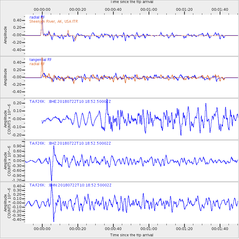
F26K Sheenjek River, AK, USA - Earthquake Result Viewer
*The percent match for this event was below the threshold and hence no stack was calculated.
| Earthquake location: |
Western Iran |
| Earthquake latitude/longitude: |
34.6/46.2 |
| Earthquake time(UTC): |
2018/07/22 (203) 10:07:27 GMT |
| Earthquake Depth: |
12 km |
| Earthquake Magnitude: |
5.8 Mww |
| Earthquake Catalog/Contributor: |
NEIC PDE/us |
|
| Network: |
TA USArray Transportable Network (new EarthScope stations) |
| Station: |
F26K Sheenjek River, AK, USA |
| Lat/Lon: |
67.69 N/144.15 W |
| Elevation: |
683 m |
|
| Distance: |
77.7 deg |
| Az: |
4.01 deg |
| Baz: |
351.308 deg |
| Ray Param: |
$rayparam |
*The percent match for this event was below the threshold and hence was not used in the summary stack. |
|
| Radial Match: |
74.2005 % |
| Radial Bump: |
400 |
| Transverse Match: |
67.861084 % |
| Transverse Bump: |
400 |
| SOD ConfigId: |
13570011 |
| Insert Time: |
2019-04-30 15:22:44.239 +0000 |
| GWidth: |
2.5 |
| Max Bumps: |
400 |
| Tol: |
0.001 |
|
Signal To Noise
| Channel | StoN | STA | LTA |
| TA:F26K: :BHZ:20180722T10:18:52.50002Z | 2.5037968 | 1.2451883E-7 | 4.9732005E-8 |
| TA:F26K: :BHN:20180722T10:18:52.50002Z | 1.6512407 | 5.432674E-8 | 3.290056E-8 |
| TA:F26K: :BHE:20180722T10:18:52.50002Z | 1.89876 | 7.072532E-8 | 3.7248164E-8 |
| Arrivals |
| Ps | |
| PpPs | |
| PsPs/PpSs | |


