You are here: Home > Network List > TA - USArray Transportable Network (new EarthScope stations) Stations List
> Station G16K Koyuk River, AK, USA > Earthquake Result Viewer
G16K Koyuk River, AK, USA - Earthquake Result Viewer
| Earthquake location: |
Western Iran |
| Earthquake latitude/longitude: |
34.6/46.2 |
| Earthquake time(UTC): |
2018/07/22 (203) 10:07:27 GMT |
| Earthquake Depth: |
12 km |
| Earthquake Magnitude: |
5.8 Mww |
| Earthquake Catalog/Contributor: |
NEIC PDE/us |
|
| Network: |
TA USArray Transportable Network (new EarthScope stations) |
| Station: |
G16K Koyuk River, AK, USA |
| Lat/Lon: |
65.39 N/162.35 W |
| Elevation: |
169 m |
|
| Distance: |
77.9 deg |
| Az: |
11.798 deg |
| Baz: |
336.242 deg |
| Ray Param: |
0.050008047 |
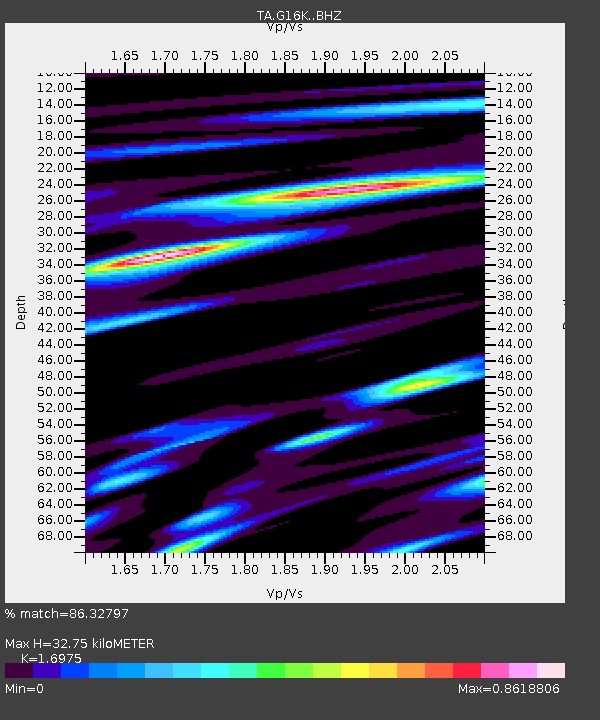
| Estimated Moho Depth: |
32.75 km |
| Estimated Crust Vp/Vs: |
1.70 |
| Assumed Crust Vp: |
6.276 km/s |
| Estimated Crust Vs: |
3.697 km/s |
| Estimated Crust Poisson's Ratio: |
0.23 |
|
| Radial Match: |
86.32797 % |
| Radial Bump: |
400 |
| Transverse Match: |
74.00038 % |
| Transverse Bump: |
400 |
| SOD ConfigId: |
13570011 |
| Insert Time: |
2019-04-30 15:22:49.009 +0000 |
| GWidth: |
2.5 |
| Max Bumps: |
400 |
| Tol: |
0.001 |
|

Signal To Noise
| Channel | StoN | STA | LTA |
| TA:G16K: :BHZ:20180722T10:18:53.425007Z | 7.251472 | 4.1485234E-7 | 5.7209398E-8 |
| TA:G16K: :BHN:20180722T10:18:53.425007Z | 2.6324673 | 1.05236914E-7 | 3.997653E-8 |
| TA:G16K: :BHE:20180722T10:18:53.425007Z | 1.9774021 | 9.6044914E-8 | 4.8571263E-8 |
| Arrivals |
| Ps | 3.8 SECOND |
| PpPs | 14 SECOND |
| PsPs/PpSs | 17 SECOND |


