You are here: Home > Network List > TA - USArray Transportable Network (new EarthScope stations) Stations List
> Station J25K Salcha River, AK, USA > Earthquake Result Viewer
J25K Salcha River, AK, USA - Earthquake Result Viewer
| Earthquake location: |
Western Iran |
| Earthquake latitude/longitude: |
34.6/46.2 |
| Earthquake time(UTC): |
2018/07/22 (203) 10:07:27 GMT |
| Earthquake Depth: |
12 km |
| Earthquake Magnitude: |
5.8 Mww |
| Earthquake Catalog/Contributor: |
NEIC PDE/us |
|
| Network: |
TA USArray Transportable Network (new EarthScope stations) |
| Station: |
J25K Salcha River, AK, USA |
| Lat/Lon: |
64.61 N/145.37 W |
| Elevation: |
949 m |
|
| Distance: |
80.7 deg |
| Az: |
5.011 deg |
| Baz: |
350.376 deg |
| Ray Param: |
0.048090015 |
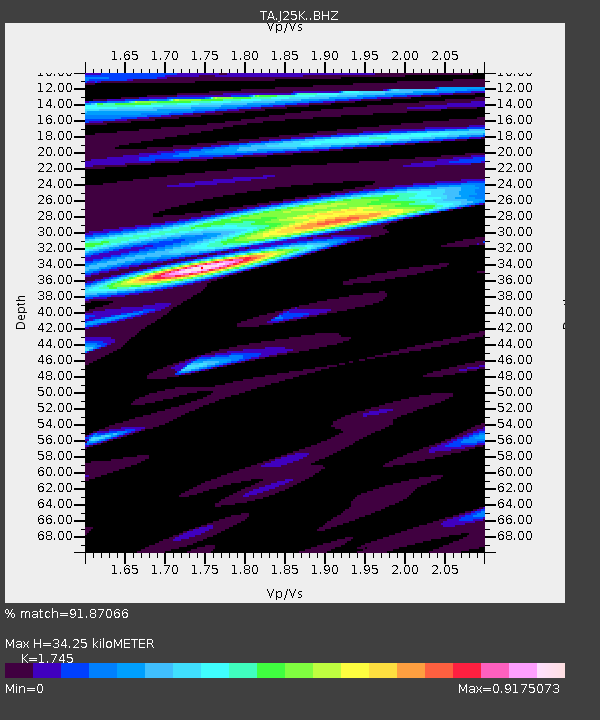
| Estimated Moho Depth: |
34.25 km |
| Estimated Crust Vp/Vs: |
1.75 |
| Assumed Crust Vp: |
6.566 km/s |
| Estimated Crust Vs: |
3.763 km/s |
| Estimated Crust Poisson's Ratio: |
0.26 |
|
| Radial Match: |
91.87066 % |
| Radial Bump: |
400 |
| Transverse Match: |
72.71445 % |
| Transverse Bump: |
400 |
| SOD ConfigId: |
13570011 |
| Insert Time: |
2019-04-30 15:23:18.549 +0000 |
| GWidth: |
2.5 |
| Max Bumps: |
400 |
| Tol: |
0.001 |
|
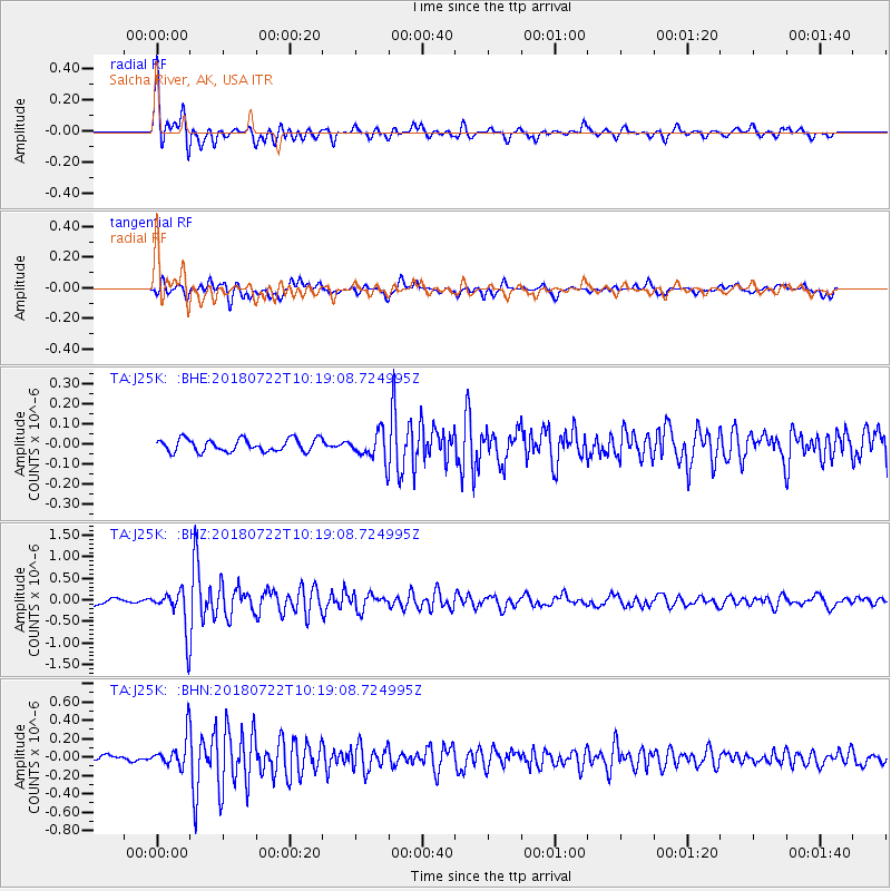
Signal To Noise
| Channel | StoN | STA | LTA |
| TA:J25K: :BHZ:20180722T10:19:08.724995Z | 7.6400733 | 4.7724814E-7 | 6.2466434E-8 |
| TA:J25K: :BHN:20180722T10:19:08.724995Z | 5.2985096 | 1.7005992E-7 | 3.20958E-8 |
| TA:J25K: :BHE:20180722T10:19:08.724995Z | 2.2013428 | 6.965525E-8 | 3.1642166E-8 |
| Arrivals |
| Ps | 4.0 SECOND |
| PpPs | 14 SECOND |
| PsPs/PpSs | 18 SECOND |


