You are here: Home > Network List > CI - Caltech Regional Seismic Network Stations List
> Station PHL Parkhill, California, USA > Earthquake Result Viewer
PHL Parkhill, California, USA - Earthquake Result Viewer
| Earthquake location: |
South Of Fiji Islands |
| Earthquake latitude/longitude: |
-23.6/-180.0 |
| Earthquake time(UTC): |
2006/02/26 (057) 03:08:27 GMT |
| Earthquake Depth: |
535 km |
| Earthquake Magnitude: |
5.9 MB, 6.4 MW, 6.4 MW |
| Earthquake Catalog/Contributor: |
WHDF/NEIC |
|
| Network: |
CI Caltech Regional Seismic Network |
| Station: |
PHL Parkhill, California, USA |
| Lat/Lon: |
35.41 N/120.55 W |
| Elevation: |
351 m |
|
| Distance: |
81.3 deg |
| Az: |
45.367 deg |
| Baz: |
233.045 deg |
| Ray Param: |
0.046097342 |
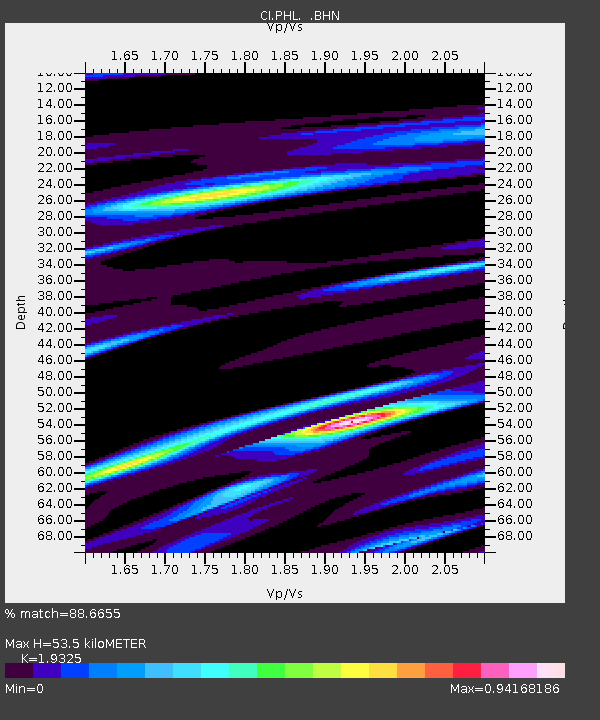
| Estimated Moho Depth: |
53.5 km |
| Estimated Crust Vp/Vs: |
1.93 |
| Assumed Crust Vp: |
6.183 km/s |
| Estimated Crust Vs: |
3.199 km/s |
| Estimated Crust Poisson's Ratio: |
0.32 |
|
| Radial Match: |
88.6655 % |
| Radial Bump: |
303 |
| Transverse Match: |
80.328186 % |
| Transverse Bump: |
382 |
| SOD ConfigId: |
2422 |
| Insert Time: |
2010-02-26 02:06:28.910 +0000 |
| GWidth: |
2.5 |
| Max Bumps: |
400 |
| Tol: |
0.001 |
|
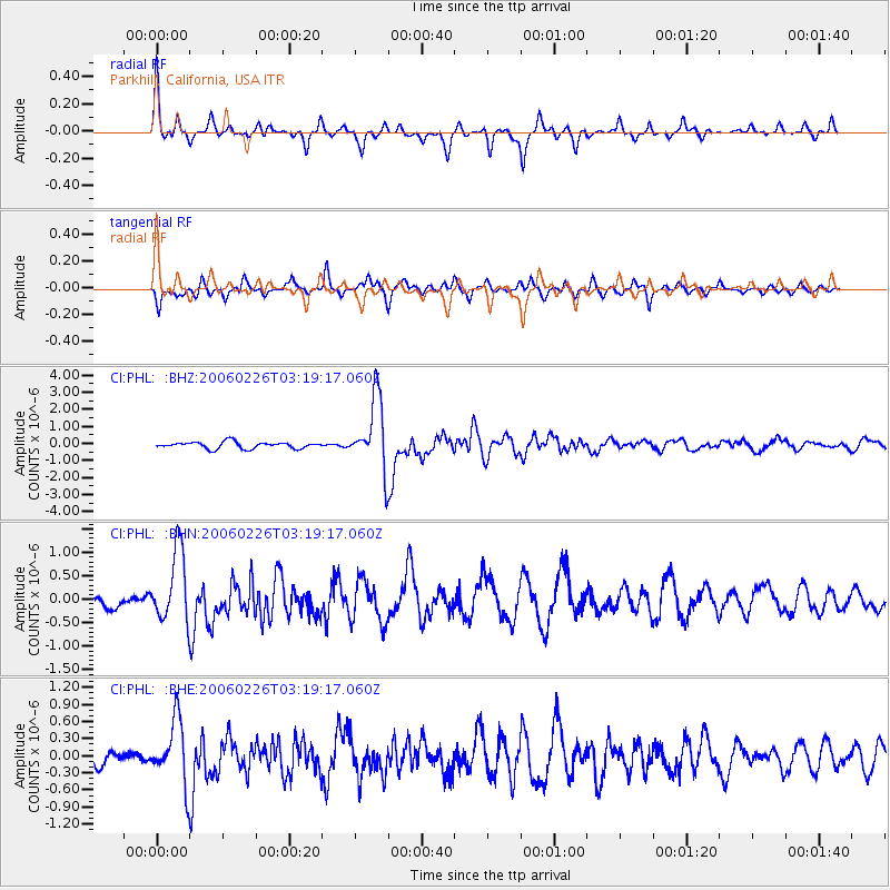
Signal To Noise
| Channel | StoN | STA | LTA |
| CI:PHL: :BHN:20060226T03:19:17.060Z | 6.86955 | 7.5792417E-7 | 1.1033097E-7 |
| CI:PHL: :BHE:20060226T03:19:17.060Z | 5.0237665 | 5.51895E-7 | 1.0985682E-7 |
| CI:PHL: :BHZ:20060226T03:19:17.060Z | 10.740691 | 2.0869184E-6 | 1.9430018E-7 |
| Arrivals |
| Ps | 8.2 SECOND |
| PpPs | 25 SECOND |
| PsPs/PpSs | 33 SECOND |


