You are here: Home > Network List > CI - Caltech Regional Seismic Network Stations List
> Station PHL Parkhill, California, USA > Earthquake Result Viewer
PHL Parkhill, California, USA - Earthquake Result Viewer
| Earthquake location: |
Near West Coast Of Colombia |
| Earthquake latitude/longitude: |
6.9/-77.8 |
| Earthquake time(UTC): |
2006/01/23 (023) 20:50:44 GMT |
| Earthquake Depth: |
14 km |
| Earthquake Magnitude: |
6.1 MB, 5.9 MS, 6.2 MW, 6.1 MW |
| Earthquake Catalog/Contributor: |
WHDF/NEIC |
|
| Network: |
CI Caltech Regional Seismic Network |
| Station: |
PHL Parkhill, California, USA |
| Lat/Lon: |
35.41 N/120.55 W |
| Elevation: |
351 m |
|
| Distance: |
48.4 deg |
| Az: |
312.127 deg |
| Baz: |
115.643 deg |
| Ray Param: |
0.06938408 |
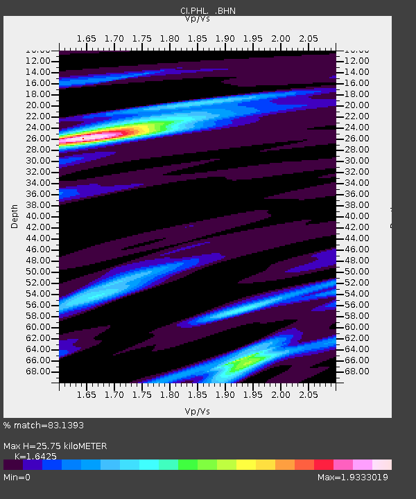
| Estimated Moho Depth: |
25.75 km |
| Estimated Crust Vp/Vs: |
1.64 |
| Assumed Crust Vp: |
6.183 km/s |
| Estimated Crust Vs: |
3.764 km/s |
| Estimated Crust Poisson's Ratio: |
0.21 |
|
| Radial Match: |
83.1393 % |
| Radial Bump: |
400 |
| Transverse Match: |
52.391056 % |
| Transverse Bump: |
400 |
| SOD ConfigId: |
4977 |
| Insert Time: |
2010-02-26 02:06:29.704 +0000 |
| GWidth: |
2.5 |
| Max Bumps: |
400 |
| Tol: |
0.001 |
|
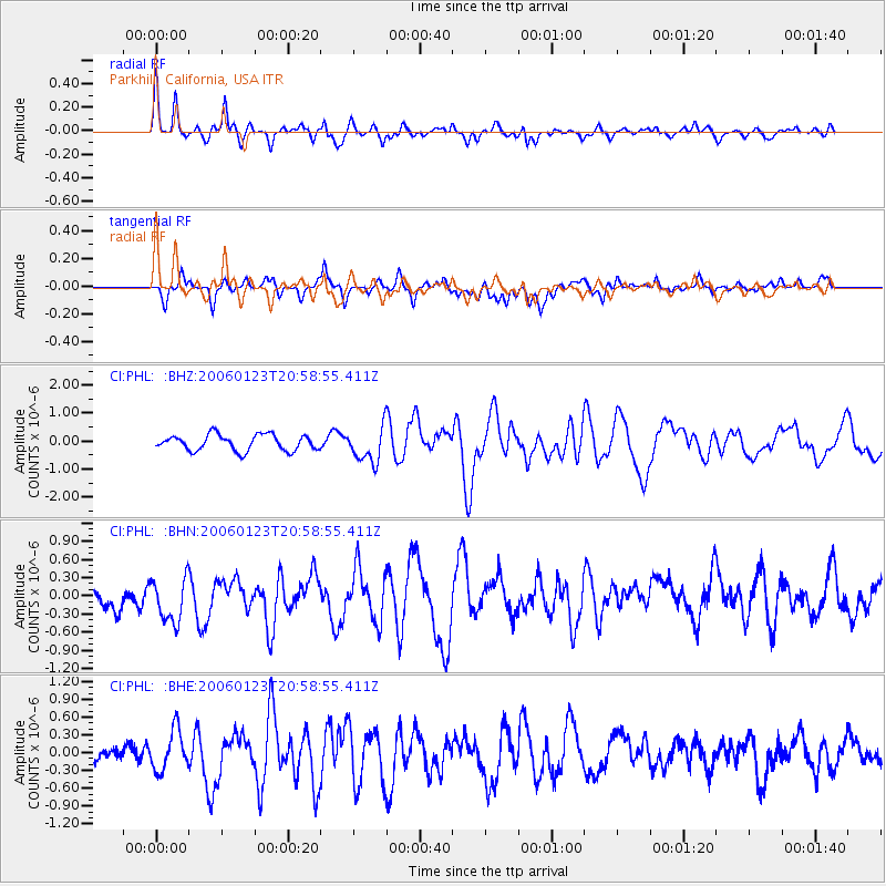
Signal To Noise
| Channel | StoN | STA | LTA |
| CI:PHL: :BHN:20060123T20:58:55.411Z | 1.8381995 | 4.236576E-7 | 2.3047424E-7 |
| CI:PHL: :BHE:20060123T20:58:55.411Z | 2.1617513 | 3.4020943E-7 | 1.5737676E-7 |
| CI:PHL: :BHZ:20060123T20:58:55.411Z | 2.188061 | 6.2014993E-7 | 2.834244E-7 |
| Arrivals |
| Ps | 2.8 SECOND |
| PpPs | 10 SECOND |
| PsPs/PpSs | 13 SECOND |


