You are here: Home > Network List > TA - USArray Transportable Network (new EarthScope stations) Stations List
> Station 224A Corundas Mountain, Dell City, TX, USA > Earthquake Result Viewer
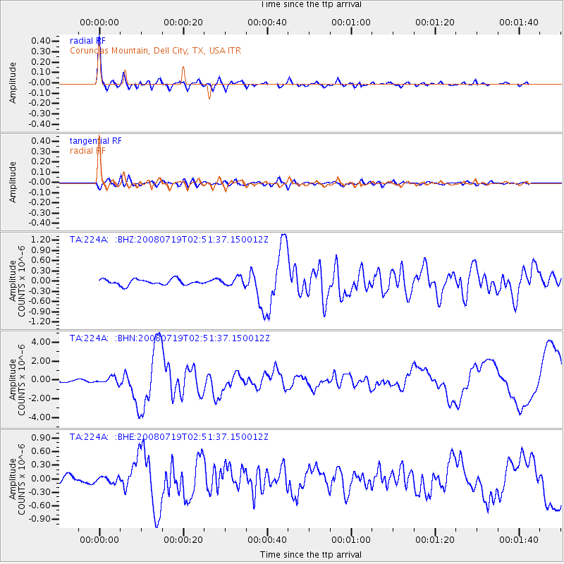
224A Corundas Mountain, Dell City, TX, USA - Earthquake Result Viewer

| Earthquake location: |
Off East Coast Of Honshu, Japan |
| Earthquake latitude/longitude: |
37.6/142.2 |
| Earthquake time(UTC): |
2008/07/19 (201) 02:39:28 GMT |
| Earthquake Depth: |
22 km |
| Earthquake Magnitude: |
6.2 MB, 7.0 MS, 7.0 MW, 6.9 MW |
| Earthquake Catalog/Contributor: |
WHDF/NEIC |
|
| Network: |
TA USArray Transportable Network (new EarthScope stations) |
| Station: |
224A Corundas Mountain, Dell City, TX, USA |
| Lat/Lon: |
32.08 N/105.52 W |
| Elevation: |
1487 m |
|
| Distance: |
86.3 deg |
| Az: |
51.936 deg |
| Baz: |
312.516 deg |
| Ray Param: |
0.0441528 |
| Estimated Moho Depth: |
43.5 km |
| Estimated Crust Vp/Vs: |
1.82 |
| Assumed Crust Vp: |
6.232 km/s |
| Estimated Crust Vs: |
3.419 km/s |
| Estimated Crust Poisson's Ratio: |
0.28 |
|
| Radial Match: |
96.464096 % |
| Radial Bump: |
400 |
| Transverse Match: |
84.80728 % |
| Transverse Bump: |
400 |
| SOD ConfigId: |
2504 |
| Insert Time: |
2010-03-06 13:04:22.706 +0000 |
| GWidth: |
2.5 |
| Max Bumps: |
400 |
| Tol: |
0.001 |
|
Signal To Noise
| Channel | StoN | STA | LTA |
| TA:224A: :BHN:20080719T02:51:37.150012Z | 2.487479 | 3.5533347E-7 | 1.4284883E-7 |
| TA:224A: :BHE:20080719T02:51:37.150012Z | 0.55312765 | 6.232809E-8 | 1.1268302E-7 |
| TA:224A: :BHZ:20080719T02:51:37.150012Z | 1.4516507 | 1.1904096E-7 | 8.200386E-8 |
| Arrivals |
| Ps | 5.9 SECOND |
| PpPs | 19 SECOND |
| PsPs/PpSs | 25 SECOND |


