You are here: Home > Network List > IU - Global Seismograph Network (GSN - IRIS/USGS) Stations List
> Station LSZ Lusaka, Zambia > Earthquake Result Viewer
LSZ Lusaka, Zambia - Earthquake Result Viewer
| Earthquake location: |
South Of Sumbawa, Indonesia |
| Earthquake latitude/longitude: |
-11.5/116.2 |
| Earthquake time(UTC): |
2016/06/09 (161) 04:13:08 GMT |
| Earthquake Depth: |
30 km |
| Earthquake Magnitude: |
6.2 MWP |
| Earthquake Catalog/Contributor: |
NEIC PDE/NEIC COMCAT |
|
| Network: |
IU Global Seismograph Network (GSN - IRIS/USGS) |
| Station: |
LSZ Lusaka, Zambia |
| Lat/Lon: |
15.28 S/28.19 E |
| Elevation: |
1200 m |
|
| Distance: |
85.2 deg |
| Az: |
255.458 deg |
| Baz: |
100.516 deg |
| Ray Param: |
0.044911064 |
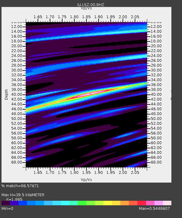
| Estimated Moho Depth: |
39.5 km |
| Estimated Crust Vp/Vs: |
1.87 |
| Assumed Crust Vp: |
6.642 km/s |
| Estimated Crust Vs: |
3.561 km/s |
| Estimated Crust Poisson's Ratio: |
0.30 |
|
| Radial Match: |
86.57671 % |
| Radial Bump: |
366 |
| Transverse Match: |
63.298447 % |
| Transverse Bump: |
400 |
| SOD ConfigId: |
1609551 |
| Insert Time: |
2016-06-23 04:13:30.326 +0000 |
| GWidth: |
2.5 |
| Max Bumps: |
400 |
| Tol: |
0.001 |
|
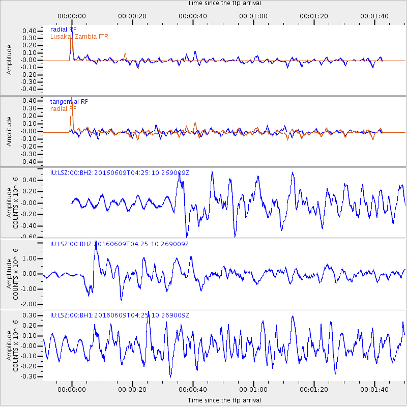
Signal To Noise
| Channel | StoN | STA | LTA |
| IU:LSZ:00:BHZ:20160609T04:25:10.269009Z | 2.7134058 | 2.7562518E-7 | 1.01579055E-7 |
| IU:LSZ:00:BH1:20160609T04:25:10.269009Z | 0.5971051 | 5.5519152E-8 | 9.2980535E-8 |
| IU:LSZ:00:BH2:20160609T04:25:10.269009Z | 1.4530559 | 9.876E-8 | 6.79671E-8 |
| Arrivals |
| Ps | 5.3 SECOND |
| PpPs | 17 SECOND |
| PsPs/PpSs | 22 SECOND |


