You are here: Home > Network List > AK - Alaska Regional Network Stations List
> Station ISLE Juniper Island, AK, USA > Earthquake Result Viewer
ISLE Juniper Island, AK, USA - Earthquake Result Viewer
| Earthquake location: |
Vanuatu Islands |
| Earthquake latitude/longitude: |
-18.9/168.9 |
| Earthquake time(UTC): |
2018/07/22 (203) 21:21:57 GMT |
| Earthquake Depth: |
100 km |
| Earthquake Magnitude: |
5.5 Mww |
| Earthquake Catalog/Contributor: |
NEIC PDE/us |
|
| Network: |
AK Alaska Regional Network |
| Station: |
ISLE Juniper Island, AK, USA |
| Lat/Lon: |
60.60 N/142.34 W |
| Elevation: |
1485 m |
|
| Distance: |
88.4 deg |
| Az: |
21.781 deg |
| Baz: |
225.388 deg |
| Ray Param: |
0.042385634 |
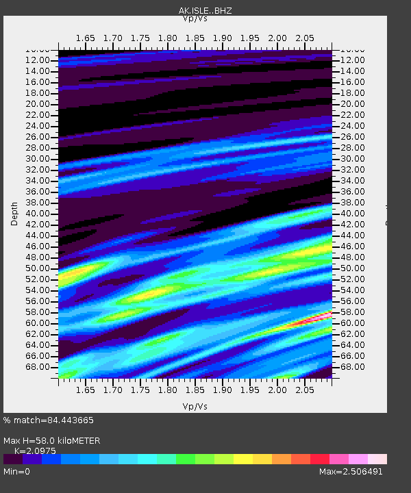
| Estimated Moho Depth: |
58.0 km |
| Estimated Crust Vp/Vs: |
2.10 |
| Assumed Crust Vp: |
6.566 km/s |
| Estimated Crust Vs: |
3.13 km/s |
| Estimated Crust Poisson's Ratio: |
0.35 |
|
| Radial Match: |
84.443665 % |
| Radial Bump: |
400 |
| Transverse Match: |
75.771 % |
| Transverse Bump: |
400 |
| SOD ConfigId: |
13570011 |
| Insert Time: |
2019-04-30 15:35:04.849 +0000 |
| GWidth: |
2.5 |
| Max Bumps: |
400 |
| Tol: |
0.001 |
|

Signal To Noise
| Channel | StoN | STA | LTA |
| AK:ISLE: :BHZ:20180722T21:34:07.068015Z | 2.1953626 | 2.7310415E-7 | 1.2440047E-7 |
| AK:ISLE: :BHN:20180722T21:34:07.068015Z | 2.0488243 | 5.450934E-7 | 2.660518E-7 |
| AK:ISLE: :BHE:20180722T21:34:07.068015Z | 0.8925533 | 3.1702302E-7 | 3.5518664E-7 |
| Arrivals |
| Ps | 9.9 SECOND |
| PpPs | 27 SECOND |
| PsPs/PpSs | 37 SECOND |


