You are here: Home > Network List > CI - Caltech Regional Seismic Network Stations List
> Station PHL Parkhill, California, USA > Earthquake Result Viewer
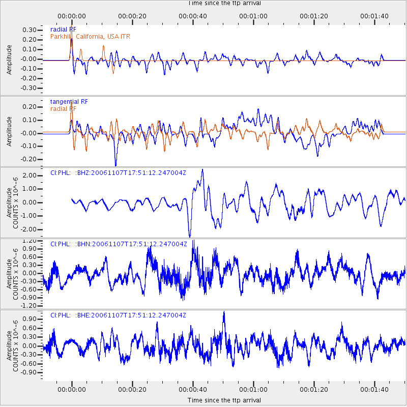
PHL Parkhill, California, USA - Earthquake Result Viewer

| Earthquake location: |
New Britain Region, P.N.G. |
| Earthquake latitude/longitude: |
-6.5/151.2 |
| Earthquake time(UTC): |
2006/11/07 (311) 17:38:33 GMT |
| Earthquake Depth: |
10 km |
| Earthquake Magnitude: |
6.2 MB, 6.3 MS, 6.5 MW, 6.4 MW |
| Earthquake Catalog/Contributor: |
WHDF/NEIC |
|
| Network: |
CI Caltech Regional Seismic Network |
| Station: |
PHL Parkhill, California, USA |
| Lat/Lon: |
35.41 N/120.55 W |
| Elevation: |
351 m |
|
| Distance: |
92.3 deg |
| Az: |
54.801 deg |
| Baz: |
263.736 deg |
| Ray Param: |
0.04147995 |
| Estimated Moho Depth: |
60.25 km |
| Estimated Crust Vp/Vs: |
1.98 |
| Assumed Crust Vp: |
6.183 km/s |
| Estimated Crust Vs: |
3.119 km/s |
| Estimated Crust Poisson's Ratio: |
0.33 |
|
| Radial Match: |
81.88975 % |
| Radial Bump: |
400 |
| Transverse Match: |
55.475292 % |
| Transverse Bump: |
400 |
| SOD ConfigId: |
2564 |
| Insert Time: |
2010-02-26 02:06:31.575 +0000 |
| GWidth: |
2.5 |
| Max Bumps: |
400 |
| Tol: |
0.001 |
|
Signal To Noise
| Channel | StoN | STA | LTA |
| CI:PHL: :BHN:20061107T17:51:12.247004Z | 0.6028531 | 1.7136962E-7 | 2.842643E-7 |
| CI:PHL: :BHE:20061107T17:51:12.247004Z | 0.96666515 | 1.7705695E-7 | 1.8316265E-7 |
| CI:PHL: :BHZ:20061107T17:51:12.247004Z | 0.96930426 | 2.3950471E-7 | 2.470893E-7 |
| Arrivals |
| Ps | 9.7 SECOND |
| PpPs | 29 SECOND |
| PsPs/PpSs | 38 SECOND |


