You are here: Home > Network List > TA - USArray Transportable Network (new EarthScope stations) Stations List
> Station 224A Corundas Mountain, Dell City, TX, USA > Earthquake Result Viewer
224A Corundas Mountain, Dell City, TX, USA - Earthquake Result Viewer

| Earthquake location: |
South Of Tonga Islands |
| Earthquake latitude/longitude: |
-24.1/-175.2 |
| Earthquake time(UTC): |
2009/11/02 (306) 10:47:13 GMT |
| Earthquake Depth: |
9.0 km |
| Earthquake Magnitude: |
6.1 MB, 6.1 MS, 6.2 MW, 6.1 MW |
| Earthquake Catalog/Contributor: |
WHDF/NEIC |
|
| Network: |
TA USArray Transportable Network (new EarthScope stations) |
| Station: |
224A Corundas Mountain, Dell City, TX, USA |
| Lat/Lon: |
32.08 N/105.52 W |
| Elevation: |
1487 m |
|
| Distance: |
86.8 deg |
| Az: |
52.86 deg |
| Baz: |
239.09 deg |
| Ray Param: |
0.043754004 |
| Estimated Moho Depth: |
51.75 km |
| Estimated Crust Vp/Vs: |
1.71 |
| Assumed Crust Vp: |
6.232 km/s |
| Estimated Crust Vs: |
3.655 km/s |
| Estimated Crust Poisson's Ratio: |
0.24 |
|
| Radial Match: |
90.29111 % |
| Radial Bump: |
295 |
| Transverse Match: |
62.99403 % |
| Transverse Bump: |
334 |
| SOD ConfigId: |
2622 |
| Insert Time: |
2010-03-06 13:05:22.610 +0000 |
| GWidth: |
2.5 |
| Max Bumps: |
400 |
| Tol: |
0.001 |
|
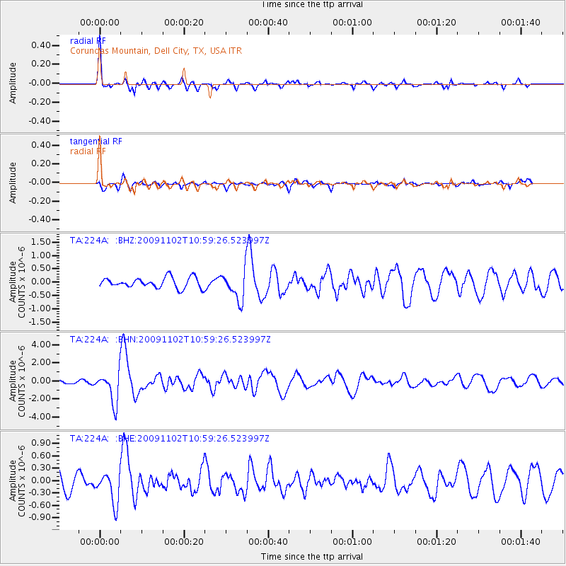
Signal To Noise
| Channel | StoN | STA | LTA |
| TA:224A: :BHN:20091102T10:59:26.523997Z | 10.409816 | 1.8015627E-6 | 1.7306384E-7 |
| TA:224A: :BHE:20091102T10:59:26.523997Z | 1.8146484 | 3.919348E-7 | 2.1598387E-7 |
| TA:224A: :BHZ:20091102T10:59:26.523997Z | 3.0204809 | 5.82985E-7 | 1.9301066E-7 |
| Arrivals |
| Ps | 6.0 SECOND |
| PpPs | 22 SECOND |
| PsPs/PpSs | 28 SECOND |


