You are here: Home > Network List > TA - USArray Transportable Network (new EarthScope stations) Stations List
> Station 224A Corundas Mountain, Dell City, TX, USA > Earthquake Result Viewer
224A Corundas Mountain, Dell City, TX, USA - Earthquake Result Viewer
| Earthquake location: |
Kuril Islands |
| Earthquake latitude/longitude: |
46.0/151.5 |
| Earthquake time(UTC): |
2009/04/07 (097) 04:23:33 GMT |
| Earthquake Depth: |
31 km |
| Earthquake Magnitude: |
6.5 MB, 6.8 MS, 6.9 MW, 6.9 MW |
| Earthquake Catalog/Contributor: |
WHDF/NEIC |
|
| Network: |
TA USArray Transportable Network (new EarthScope stations) |
| Station: |
224A Corundas Mountain, Dell City, TX, USA |
| Lat/Lon: |
32.08 N/105.52 W |
| Elevation: |
1487 m |
|
| Distance: |
75.7 deg |
| Az: |
58.635 deg |
| Baz: |
315.533 deg |
| Ray Param: |
0.051446978 |
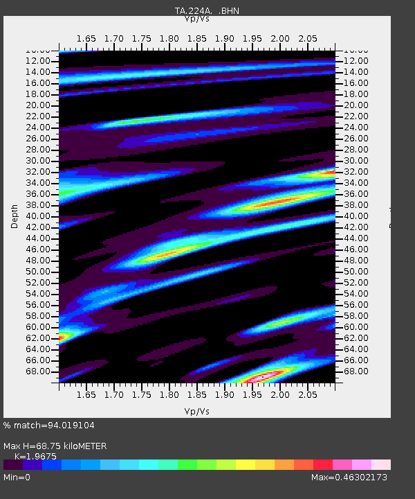
| Estimated Moho Depth: |
68.75 km |
| Estimated Crust Vp/Vs: |
1.97 |
| Assumed Crust Vp: |
6.232 km/s |
| Estimated Crust Vs: |
3.167 km/s |
| Estimated Crust Poisson's Ratio: |
0.33 |
|
| Radial Match: |
94.019104 % |
| Radial Bump: |
295 |
| Transverse Match: |
86.97816 % |
| Transverse Bump: |
400 |
| SOD ConfigId: |
2658 |
| Insert Time: |
2010-03-06 13:05:38.145 +0000 |
| GWidth: |
2.5 |
| Max Bumps: |
400 |
| Tol: |
0.001 |
|

Signal To Noise
| Channel | StoN | STA | LTA |
| TA:224A: :BHN:20090407T04:34:44.475012Z | 11.718815 | 3.3625133E-6 | 2.869329E-7 |
| TA:224A: :BHE:20090407T04:34:44.475012Z | 5.819322 | 9.116748E-7 | 1.566634E-7 |
| TA:224A: :BHZ:20090407T04:34:44.475012Z | 6.8161664 | 1.0776962E-6 | 1.5810885E-7 |
| Arrivals |
| Ps | 11 SECOND |
| PpPs | 32 SECOND |
| PsPs/PpSs | 43 SECOND |


